You are here: Home > Network List > TA - USArray Transportable Network (new EarthScope stations) Stations List
> Station F20K Avaraart Lake, AK, USA > Earthquake Result Viewer
F20K Avaraart Lake, AK, USA - Earthquake Result Viewer
| Earthquake location: |
North Of Halmahera, Indonesia |
| Earthquake latitude/longitude: |
3.0/128.0 |
| Earthquake time(UTC): |
2020/03/18 (078) 03:13:29 GMT |
| Earthquake Depth: |
102 km |
| Earthquake Magnitude: |
5.4 Mww |
| Earthquake Catalog/Contributor: |
NEIC PDE/us |
|
| Network: |
TA USArray Transportable Network (new EarthScope stations) |
| Station: |
F20K Avaraart Lake, AK, USA |
| Lat/Lon: |
67.05 N/155.73 W |
| Elevation: |
136 m |
|
| Distance: |
81.9 deg |
| Az: |
22.63 deg |
| Baz: |
258.461 deg |
| Ray Param: |
0.047058385 |
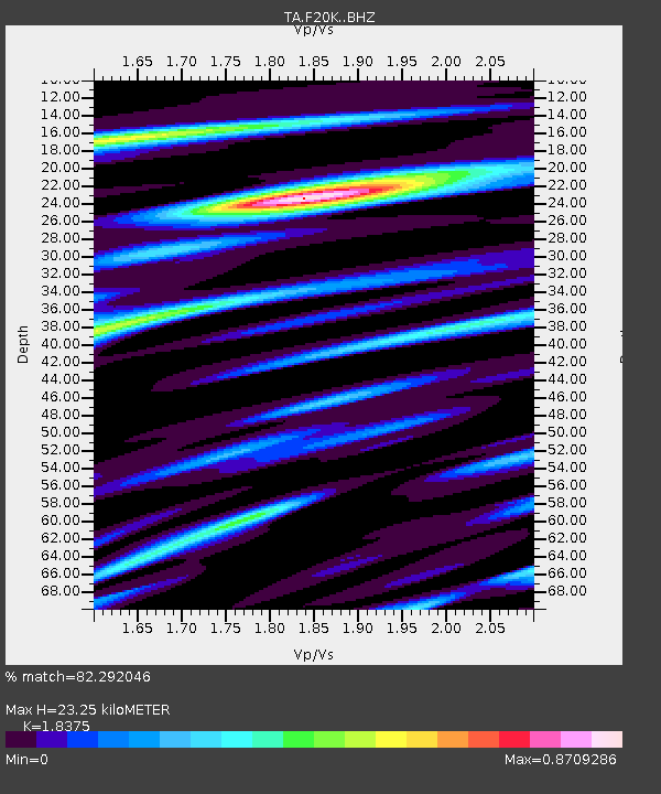
| Estimated Moho Depth: |
23.25 km |
| Estimated Crust Vp/Vs: |
1.84 |
| Assumed Crust Vp: |
6.522 km/s |
| Estimated Crust Vs: |
3.549 km/s |
| Estimated Crust Poisson's Ratio: |
0.29 |
|
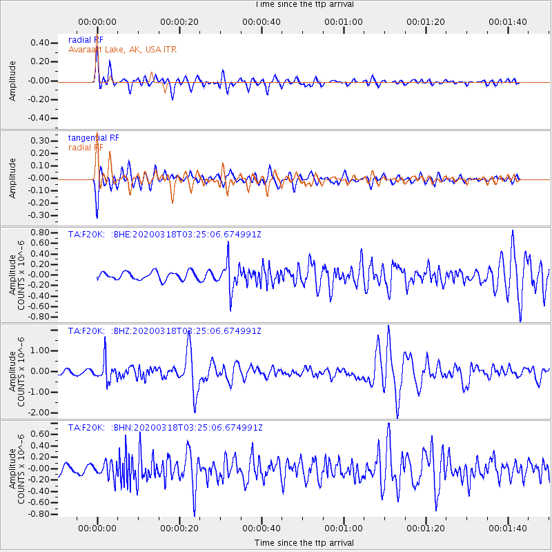
| Radial Match: |
82.292046 % |
| Radial Bump: |
400 |
| Transverse Match: |
73.72544 % |
| Transverse Bump: |
400 |
| SOD ConfigId: |
20906531 |
| Insert Time: |
2020-04-08 11:42:31.532 +0000 |
| GWidth: |
2.5 |
| Max Bumps: |
400 |
| Tol: |
0.001 |
|
Signal To Noise
| Channel | StoN | STA | LTA |
| TA:F20K: :BHZ:20200318T03:25:06.674991Z | 4.782368 | 4.9221245E-7 | 1.0292232E-7 |
| TA:F20K: :BHN:20200318T03:25:06.674991Z | 1.5697132 | 1.3010009E-7 | 8.2881435E-8 |
| TA:F20K: :BHE:20200318T03:25:06.674991Z | 3.5577497 | 2.6436064E-7 | 7.430557E-8 |
| Arrivals |
| Ps | 3.1 SECOND |
| PpPs | 9.9 SECOND |
| PsPs/PpSs | 13 SECOND |


