You are here: Home > Network List > TA - USArray Transportable Network (new EarthScope stations) Stations List
> Station G17K Kiwalik Mountain, AK, USA > Earthquake Result Viewer
G17K Kiwalik Mountain, AK, USA - Earthquake Result Viewer
| Earthquake location: |
North Of Halmahera, Indonesia |
| Earthquake latitude/longitude: |
3.0/128.0 |
| Earthquake time(UTC): |
2020/03/18 (078) 03:13:29 GMT |
| Earthquake Depth: |
102 km |
| Earthquake Magnitude: |
5.4 Mww |
| Earthquake Catalog/Contributor: |
NEIC PDE/us |
|
| Network: |
TA USArray Transportable Network (new EarthScope stations) |
| Station: |
G17K Kiwalik Mountain, AK, USA |
| Lat/Lon: |
65.50 N/160.65 W |
| Elevation: |
338 m |
|
| Distance: |
79.6 deg |
| Az: |
23.68 deg |
| Baz: |
254.124 deg |
| Ray Param: |
0.048647165 |
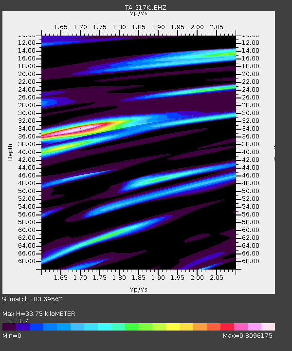
| Estimated Moho Depth: |
33.75 km |
| Estimated Crust Vp/Vs: |
1.70 |
| Assumed Crust Vp: |
6.276 km/s |
| Estimated Crust Vs: |
3.692 km/s |
| Estimated Crust Poisson's Ratio: |
0.24 |
|
| Radial Match: |
83.69562 % |
| Radial Bump: |
381 |
| Transverse Match: |
76.48066 % |
| Transverse Bump: |
400 |
| SOD ConfigId: |
20906531 |
| Insert Time: |
2020-04-08 11:42:43.279 +0000 |
| GWidth: |
2.5 |
| Max Bumps: |
400 |
| Tol: |
0.001 |
|

Signal To Noise
| Channel | StoN | STA | LTA |
| TA:G17K: :BHZ:20200318T03:24:54.450016Z | 5.6329494 | 4.5060324E-7 | 7.9994194E-8 |
| TA:G17K: :BHN:20200318T03:24:54.450016Z | 0.9127223 | 5.6395876E-8 | 6.178865E-8 |
| TA:G17K: :BHE:20200318T03:24:54.450016Z | 1.4025248 | 1.4731991E-7 | 1.0503908E-7 |
| Arrivals |
| Ps | 3.9 SECOND |
| PpPs | 14 SECOND |
| PsPs/PpSs | 18 SECOND |


