You are here: Home > Network List > TA - USArray Transportable Network (new EarthScope stations) Stations List
> Station G21K Allakaket, AK, USA > Earthquake Result Viewer
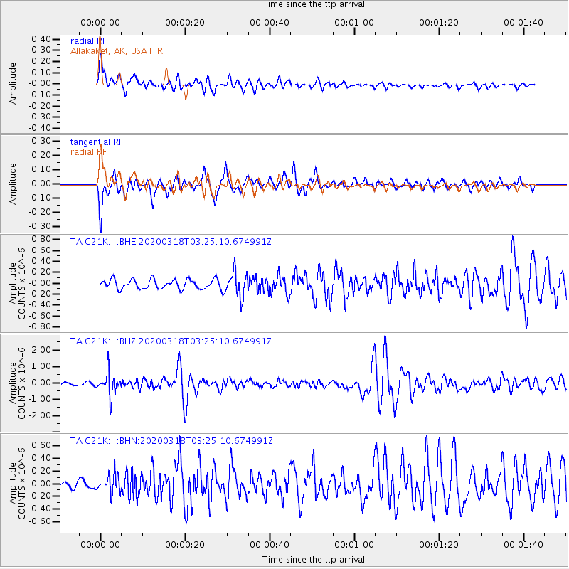
G21K Allakaket, AK, USA - Earthquake Result Viewer
*The percent match for this event was below the threshold and hence no stack was calculated.
| Earthquake location: |
North Of Halmahera, Indonesia |
| Earthquake latitude/longitude: |
3.0/128.0 |
| Earthquake time(UTC): |
2020/03/18 (078) 03:13:29 GMT |
| Earthquake Depth: |
102 km |
| Earthquake Magnitude: |
5.4 Mww |
| Earthquake Catalog/Contributor: |
NEIC PDE/us |
|
| Network: |
TA USArray Transportable Network (new EarthScope stations) |
| Station: |
G21K Allakaket, AK, USA |
| Lat/Lon: |
66.52 N/153.51 W |
| Elevation: |
446 m |
|
| Distance: |
82.6 deg |
| Az: |
23.323 deg |
| Baz: |
260.591 deg |
| Ray Param: |
$rayparam |
*The percent match for this event was below the threshold and hence was not used in the summary stack. |
|
| Radial Match: |
74.56514 % |
| Radial Bump: |
400 |
| Transverse Match: |
74.07573 % |
| Transverse Bump: |
400 |
| SOD ConfigId: |
20906531 |
| Insert Time: |
2020-04-08 11:42:46.828 +0000 |
| GWidth: |
2.5 |
| Max Bumps: |
400 |
| Tol: |
0.001 |
|
Signal To Noise
| Channel | StoN | STA | LTA |
| TA:G21K: :BHZ:20200318T03:25:10.674991Z | 9.817632 | 6.9768356E-7 | 7.106434E-8 |
| TA:G21K: :BHN:20200318T03:25:10.674991Z | 1.6982579 | 1.3666038E-7 | 8.047092E-8 |
| TA:G21K: :BHE:20200318T03:25:10.674991Z | 2.6668928 | 2.2200035E-7 | 8.324308E-8 |
| Arrivals |
| Ps | |
| PpPs | |
| PsPs/PpSs | |


