You are here: Home > Network List > TA - USArray Transportable Network (new EarthScope stations) Stations List
> Station M22K Willow, AK, USA > Earthquake Result Viewer
M22K Willow, AK, USA - Earthquake Result Viewer
| Earthquake location: |
North Of Halmahera, Indonesia |
| Earthquake latitude/longitude: |
3.0/128.0 |
| Earthquake time(UTC): |
2020/03/18 (078) 03:13:29 GMT |
| Earthquake Depth: |
102 km |
| Earthquake Magnitude: |
5.4 Mww |
| Earthquake Catalog/Contributor: |
NEIC PDE/us |
|
| Network: |
TA USArray Transportable Network (new EarthScope stations) |
| Station: |
M22K Willow, AK, USA |
| Lat/Lon: |
61.75 N/150.12 W |
| Elevation: |
57 m |
|
| Distance: |
83.5 deg |
| Az: |
28.293 deg |
| Baz: |
264.237 deg |
| Ray Param: |
0.045934606 |
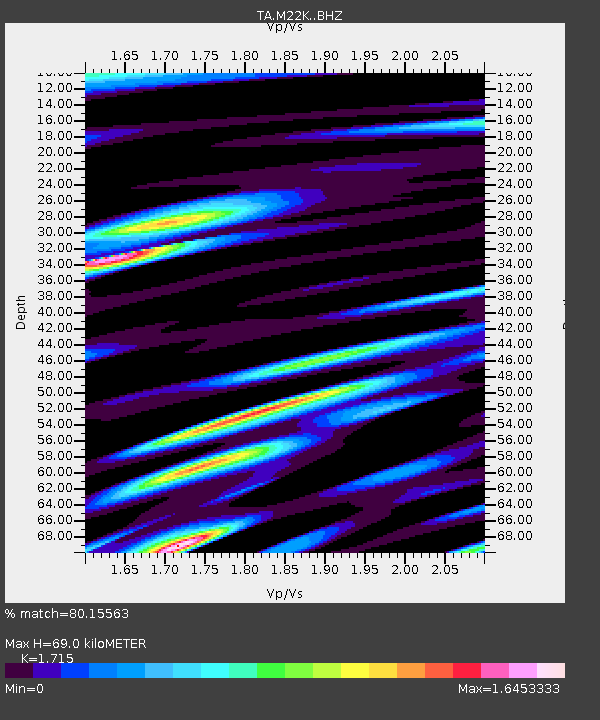
| Estimated Moho Depth: |
69.0 km |
| Estimated Crust Vp/Vs: |
1.72 |
| Assumed Crust Vp: |
6.302 km/s |
| Estimated Crust Vs: |
3.674 km/s |
| Estimated Crust Poisson's Ratio: |
0.24 |
|
| Radial Match: |
80.15563 % |
| Radial Bump: |
400 |
| Transverse Match: |
79.228455 % |
| Transverse Bump: |
400 |
| SOD ConfigId: |
20906531 |
| Insert Time: |
2020-04-08 11:43:37.824 +0000 |
| GWidth: |
2.5 |
| Max Bumps: |
400 |
| Tol: |
0.001 |
|

Signal To Noise
| Channel | StoN | STA | LTA |
| TA:M22K: :BHZ:20200318T03:25:14.974979Z | 20.844378 | 2.6767207E-6 | 1.2841453E-7 |
| TA:M22K: :BHN:20200318T03:25:14.974979Z | 4.3324842 | 1.5569796E-6 | 3.593734E-7 |
| TA:M22K: :BHE:20200318T03:25:14.974979Z | 5.8815174 | 1.8340899E-6 | 3.1183956E-7 |
| Arrivals |
| Ps | 8.0 SECOND |
| PpPs | 29 SECOND |
| PsPs/PpSs | 37 SECOND |


