You are here: Home > Network List > TA - USArray Transportable Network (new EarthScope stations) Stations List
> Station N25K Chitina, Valdez-Cordova, AK, USA > Earthquake Result Viewer
N25K Chitina, Valdez-Cordova, AK, USA - Earthquake Result Viewer
| Earthquake location: |
North Of Halmahera, Indonesia |
| Earthquake latitude/longitude: |
3.0/128.0 |
| Earthquake time(UTC): |
2020/03/18 (078) 03:13:29 GMT |
| Earthquake Depth: |
102 km |
| Earthquake Magnitude: |
5.4 Mww |
| Earthquake Catalog/Contributor: |
NEIC PDE/us |
|
| Network: |
TA USArray Transportable Network (new EarthScope stations) |
| Station: |
N25K Chitina, Valdez-Cordova, AK, USA |
| Lat/Lon: |
61.61 N/144.60 W |
| Elevation: |
1087 m |
|
| Distance: |
86.1 deg |
| Az: |
28.594 deg |
| Baz: |
269.119 deg |
| Ray Param: |
0.044078633 |
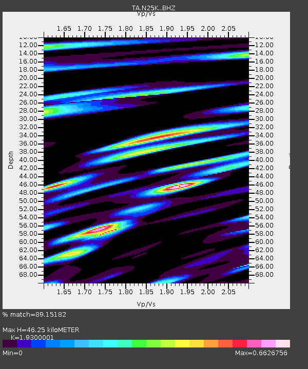
| Estimated Moho Depth: |
46.25 km |
| Estimated Crust Vp/Vs: |
1.93 |
| Assumed Crust Vp: |
6.566 km/s |
| Estimated Crust Vs: |
3.402 km/s |
| Estimated Crust Poisson's Ratio: |
0.32 |
|
| Radial Match: |
89.15182 % |
| Radial Bump: |
400 |
| Transverse Match: |
90.14883 % |
| Transverse Bump: |
396 |
| SOD ConfigId: |
20906531 |
| Insert Time: |
2020-04-08 11:43:54.152 +0000 |
| GWidth: |
2.5 |
| Max Bumps: |
400 |
| Tol: |
0.001 |
|
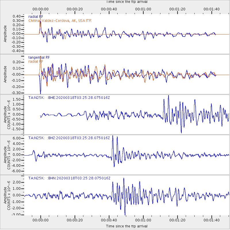
Signal To Noise
| Channel | StoN | STA | LTA |
| TA:N25K: :BHZ:20200318T03:25:28.075016Z | 5.004727 | 5.25438E-7 | 1.0498835E-7 |
| TA:N25K: :BHN:20200318T03:25:28.075016Z | 3.1912706 | 2.9431916E-7 | 9.222633E-8 |
| TA:N25K: :BHE:20200318T03:25:28.075016Z | 2.8168433 | 2.5138615E-7 | 8.9243926E-8 |
| Arrivals |
| Ps | 6.7 SECOND |
| PpPs | 20 SECOND |
| PsPs/PpSs | 27 SECOND |


