You are here: Home > Network List > TS - TERRAscope (Southern California Seismic Network) Stations List
> Station PFO Pinon Flat, California, USA > Earthquake Result Viewer
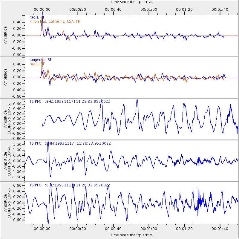
PFO Pinon Flat, California, USA - Earthquake Result Viewer
*The percent match for this event was below the threshold and hence no stack was calculated.
| Earthquake location: |
Near East Coast Of Kamchatka |
| Earthquake latitude/longitude: |
51.8/158.7 |
| Earthquake time(UTC): |
1993/11/17 (321) 11:18:52 GMT |
| Earthquake Depth: |
44 km |
| Earthquake Magnitude: |
6.0 MB, 5.6 MS |
| Earthquake Catalog/Contributor: |
WHDF/NEIC |
|
| Network: |
TS TERRAscope (Southern California Seismic Network) |
| Station: |
PFO Pinon Flat, California, USA |
| Lat/Lon: |
33.61 N/116.46 W |
| Elevation: |
1280 m |
|
| Distance: |
61.4 deg |
| Az: |
71.178 deg |
| Baz: |
315.233 deg |
| Ray Param: |
$rayparam |
*The percent match for this event was below the threshold and hence was not used in the summary stack. |
|
| Radial Match: |
69.81526 % |
| Radial Bump: |
329 |
| Transverse Match: |
76.77877 % |
| Transverse Bump: |
362 |
| SOD ConfigId: |
4480 |
| Insert Time: |
2010-02-26 14:44:23.311 +0000 |
| GWidth: |
2.5 |
| Max Bumps: |
400 |
| Tol: |
0.001 |
|
Signal To Noise
| Channel | StoN | STA | LTA |
| TS:PFO: :BHN:19931117T11:28:33.952002Z | 3.8712313 | 7.942565E-7 | 2.0516896E-7 |
| TS:PFO: :BHE:19931117T11:28:33.952002Z | 2.0106301 | 3.330841E-7 | 1.6566155E-7 |
| TS:PFO: :BHZ:19931117T11:28:33.952002Z | 2.2605622 | 3.6611434E-7 | 1.6195719E-7 |
| Arrivals |
| Ps | |
| PpPs | |
| PsPs/PpSs | |


