You are here: Home > Network List > AK - Alaska Regional Network Stations List
> Station MDM Murphy Dome > Earthquake Result Viewer
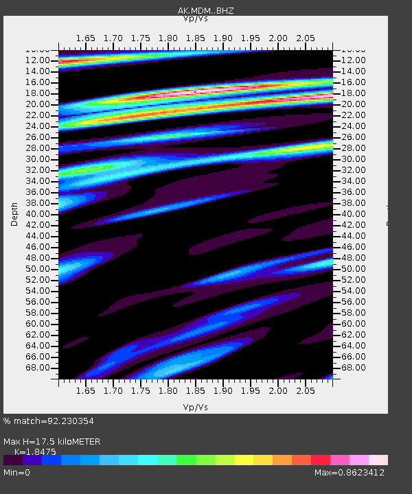
MDM Murphy Dome - Earthquake Result Viewer
| Earthquake location: |
Vanuatu Islands |
| Earthquake latitude/longitude: |
-13.1/167.0 |
| Earthquake time(UTC): |
2020/03/18 (078) 03:13:45 GMT |
| Earthquake Depth: |
176 km |
| Earthquake Magnitude: |
6.1 mww |
| Earthquake Catalog/Contributor: |
NEIC PDE/us |
|
| Network: |
AK Alaska Regional Network |
| Station: |
MDM Murphy Dome |
| Lat/Lon: |
64.96 N/148.23 W |
| Elevation: |
634 m |
|
| Distance: |
84.8 deg |
| Az: |
17.507 deg |
| Baz: |
223.515 deg |
| Ray Param: |
0.0447882 |
| Estimated Moho Depth: |
17.5 km |
| Estimated Crust Vp/Vs: |
1.85 |
| Assumed Crust Vp: |
6.566 km/s |
| Estimated Crust Vs: |
3.554 km/s |
| Estimated Crust Poisson's Ratio: |
0.29 |
|
| Radial Match: |
92.230354 % |
| Radial Bump: |
307 |
| Transverse Match: |
89.002495 % |
| Transverse Bump: |
382 |
| SOD ConfigId: |
20906531 |
| Insert Time: |
2020-04-08 11:46:58.278 +0000 |
| GWidth: |
2.5 |
| Max Bumps: |
400 |
| Tol: |
0.001 |
|

Signal To Noise
| Channel | StoN | STA | LTA |
| AK:MDM: :BHZ:20200318T03:25:29.247981Z | 7.644455 | 1.2814559E-6 | 1.6763208E-7 |
| AK:MDM: :BHN:20200318T03:25:29.247981Z | 4.3752456 | 3.5709803E-7 | 8.161782E-8 |
| AK:MDM: :BHE:20200318T03:25:29.247981Z | 4.6487565 | 3.401536E-7 | 7.317088E-8 |
| Arrivals |
| Ps | 2.3 SECOND |
| PpPs | 7.4 SECOND |
| PsPs/PpSs | 9.7 SECOND |


