You are here: Home > Network List > US - United States National Seismic Network Stations List
> Station OXF Oxford, Mississippi, USA > Earthquake Result Viewer
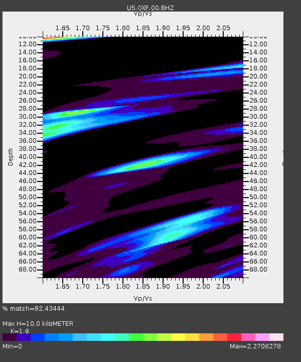
OXF Oxford, Mississippi, USA - Earthquake Result Viewer
| Earthquake location: |
Andreanof Islands, Aleutian Is. |
| Earthquake latitude/longitude: |
51.4/-178.6 |
| Earthquake time(UTC): |
2017/05/08 (128) 17:00:42 GMT |
| Earthquake Depth: |
1.0 km |
| Earthquake Magnitude: |
6.6 Mi |
| Earthquake Catalog/Contributor: |
NEIC PDE/at |
|
| Network: |
US United States National Seismic Network |
| Station: |
OXF Oxford, Mississippi, USA |
| Lat/Lon: |
34.51 N/89.41 W |
| Elevation: |
101 m |
|
| Distance: |
63.5 deg |
| Az: |
67.359 deg |
| Baz: |
315.503 deg |
| Ray Param: |
0.059580952 |
| Estimated Moho Depth: |
10.0 km |
| Estimated Crust Vp/Vs: |
1.60 |
| Assumed Crust Vp: |
6.38 km/s |
| Estimated Crust Vs: |
3.988 km/s |
| Estimated Crust Poisson's Ratio: |
0.18 |
|
| Radial Match: |
92.43444 % |
| Radial Bump: |
307 |
| Transverse Match: |
83.20111 % |
| Transverse Bump: |
400 |
| SOD ConfigId: |
2028011 |
| Insert Time: |
2017-05-22 17:05:22.117 +0000 |
| GWidth: |
2.5 |
| Max Bumps: |
400 |
| Tol: |
0.001 |
|

Signal To Noise
| Channel | StoN | STA | LTA |
| US:OXF:00:BHZ:20170508T17:10:42.273987Z | 2.1943967 | 4.1781038E-7 | 1.9039875E-7 |
| US:OXF:00:BH1:20170508T17:10:42.273987Z | 0.91048044 | 2.881078E-7 | 3.1643492E-7 |
| US:OXF:00:BH2:20170508T17:10:42.273987Z | 0.7881583 | 3.076722E-7 | 3.9036854E-7 |
| Arrivals |
| Ps | 1.0 SECOND |
| PpPs | 3.9 SECOND |
| PsPs/PpSs | 4.9 SECOND |


