You are here: Home > Network List > UU - University of Utah Regional Network Stations List
> Station TCRU Three Creek Reservoir, UT, USA > Earthquake Result Viewer
TCRU Three Creek Reservoir, UT, USA - Earthquake Result Viewer
| Earthquake location: |
Andreanof Islands, Aleutian Is. |
| Earthquake latitude/longitude: |
51.4/-178.6 |
| Earthquake time(UTC): |
2017/05/08 (128) 17:00:42 GMT |
| Earthquake Depth: |
1.0 km |
| Earthquake Magnitude: |
6.6 Mi |
| Earthquake Catalog/Contributor: |
NEIC PDE/at |
|
| Network: |
UU University of Utah Regional Network |
| Station: |
TCRU Three Creek Reservoir, UT, USA |
| Lat/Lon: |
38.61 N/112.45 W |
| Elevation: |
2293 m |
|
| Distance: |
46.9 deg |
| Az: |
78.728 deg |
| Baz: |
308.281 deg |
| Ray Param: |
0.07035004 |
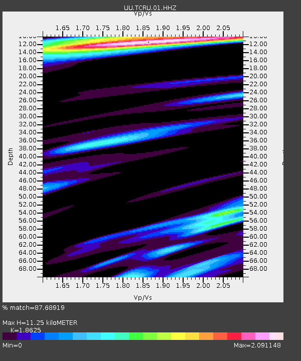
| Estimated Moho Depth: |
11.25 km |
| Estimated Crust Vp/Vs: |
1.86 |
| Assumed Crust Vp: |
6.276 km/s |
| Estimated Crust Vs: |
3.37 km/s |
| Estimated Crust Poisson's Ratio: |
0.30 |
|
| Radial Match: |
87.68919 % |
| Radial Bump: |
400 |
| Transverse Match: |
54.740757 % |
| Transverse Bump: |
400 |
| SOD ConfigId: |
2028011 |
| Insert Time: |
2017-05-22 17:05:47.576 +0000 |
| GWidth: |
2.5 |
| Max Bumps: |
400 |
| Tol: |
0.001 |
|

Signal To Noise
| Channel | StoN | STA | LTA |
| UU:TCRU:01:HHZ:20170508T17:08:43.200012Z | 1.0830476 | 9.910355E-9 | 9.150433E-9 |
| UU:TCRU:01:HHN:20170508T17:08:43.200012Z | 1.2897435 | 1.6377468E-8 | 1.2698236E-8 |
| UU:TCRU:01:HHE:20170508T17:08:43.200012Z | 1.2370456 | 1.629011E-8 | 1.3168562E-8 |
| Arrivals |
| Ps | 1.6 SECOND |
| PpPs | 4.9 SECOND |
| PsPs/PpSs | 6.5 SECOND |


