You are here: Home > Network List > TS - TERRAscope (Southern California Seismic Network) Stations List
> Station PFO Pinon Flat, California, USA > Earthquake Result Viewer
PFO Pinon Flat, California, USA - Earthquake Result Viewer
*The percent match for this event was below the threshold and hence no stack was calculated.
| Earthquake location: |
Solomon Islands |
| Earthquake latitude/longitude: |
-9.6/158.1 |
| Earthquake time(UTC): |
1993/11/26 (330) 23:20:05 GMT |
| Earthquake Depth: |
23 km |
| Earthquake Magnitude: |
5.8 MB, 6.2 MS, 6.1 UNKNOWN, 6.3 MW |
| Earthquake Catalog/Contributor: |
WHDF/NEIC |
|
| Network: |
TS TERRAscope (Southern California Seismic Network) |
| Station: |
PFO Pinon Flat, California, USA |
| Lat/Lon: |
33.61 N/116.46 W |
| Elevation: |
1280 m |
|
| Distance: |
91.4 deg |
| Az: |
56.317 deg |
| Baz: |
259.529 deg |
| Ray Param: |
$rayparam |
*The percent match for this event was below the threshold and hence was not used in the summary stack. |
|
| Radial Match: |
84.06411 % |
| Radial Bump: |
339 |
| Transverse Match: |
82.20739 % |
| Transverse Bump: |
236 |
| SOD ConfigId: |
4480 |
| Insert Time: |
2010-02-26 14:44:23.720 +0000 |
| GWidth: |
2.5 |
| Max Bumps: |
400 |
| Tol: |
0.001 |
|
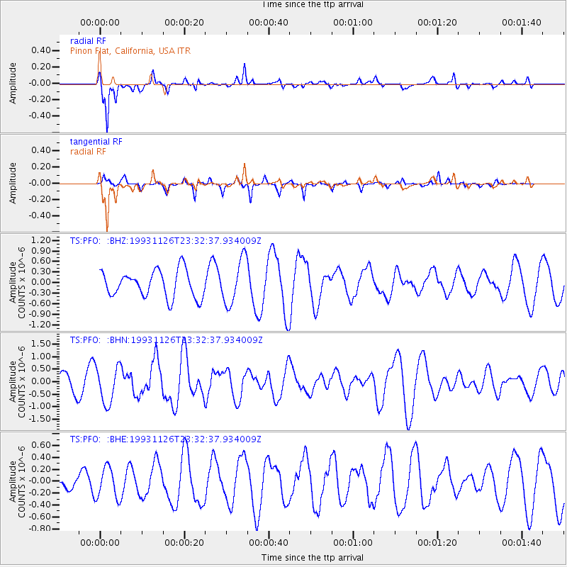
Signal To Noise
| Channel | StoN | STA | LTA |
| TS:PFO: :BHN:19931126T23:32:37.934009Z | 1.944457 | 7.3155485E-7 | 3.7622578E-7 |
| TS:PFO: :BHE:19931126T23:32:37.934009Z | 2.5262198 | 2.6056918E-7 | 1.0314588E-7 |
| TS:PFO: :BHZ:19931126T23:32:37.934009Z | 1.747955 | 6.616286E-7 | 3.785158E-7 |
| Arrivals |
| Ps | |
| PpPs | |
| PsPs/PpSs | |


