You are here: Home > Network List > TS - TERRAscope (Southern California Seismic Network) Stations List
> Station PFO Pinon Flat, California, USA > Earthquake Result Viewer
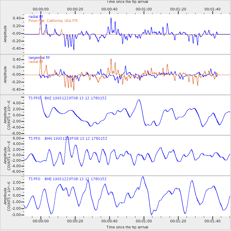
PFO Pinon Flat, California, USA - Earthquake Result Viewer
*The percent match for this event was below the threshold and hence no stack was calculated.
| Earthquake location: |
Vanuatu Islands |
| Earthquake latitude/longitude: |
-20.0/169.7 |
| Earthquake time(UTC): |
1993/12/29 (363) 08:00:55 GMT |
| Earthquake Depth: |
33 km |
| Earthquake Magnitude: |
5.8 MB |
| Earthquake Catalog/Contributor: |
WHDF/NEIC |
|
| Network: |
TS TERRAscope (Southern California Seismic Network) |
| Station: |
PFO Pinon Flat, California, USA |
| Lat/Lon: |
33.61 N/116.46 W |
| Elevation: |
1280 m |
|
| Distance: |
88.3 deg |
| Az: |
53.327 deg |
| Baz: |
244.627 deg |
| Ray Param: |
$rayparam |
*The percent match for this event was below the threshold and hence was not used in the summary stack. |
|
| Radial Match: |
67.70134 % |
| Radial Bump: |
316 |
| Transverse Match: |
42.277847 % |
| Transverse Bump: |
257 |
| SOD ConfigId: |
4480 |
| Insert Time: |
2010-02-26 14:44:25.011 +0000 |
| GWidth: |
2.5 |
| Max Bumps: |
400 |
| Tol: |
0.001 |
|
Signal To Noise
| Channel | StoN | STA | LTA |
| TS:PFO: :BHN:19931229T08:13:12.178015Z | 2.0896506 | 2.2517597E-6 | 1.0775772E-6 |
| TS:PFO: :BHE:19931229T08:13:12.178015Z | 0.868101 | 1.1794627E-6 | 1.3586699E-6 |
| TS:PFO: :BHZ:19931229T08:13:12.178015Z | 2.5999768 | 3.6666788E-6 | 1.4102736E-6 |
| Arrivals |
| Ps | |
| PpPs | |
| PsPs/PpSs | |


