You are here: Home > Network List > CU - Caribbean Network (USGS) Stations List
> Station TGUH Tegucigalpa, Honduras > Earthquake Result Viewer
TGUH Tegucigalpa, Honduras - Earthquake Result Viewer
| Earthquake location: |
Andreanof Islands, Aleutian Is. |
| Earthquake latitude/longitude: |
51.4/-178.6 |
| Earthquake time(UTC): |
2017/05/08 (128) 17:01:00 GMT |
| Earthquake Depth: |
1.6 km |
| Earthquake Magnitude: |
6.6 Mi |
| Earthquake Catalog/Contributor: |
NEIC PDE/pt |
|
| Network: |
CU Caribbean Network (USGS) |
| Station: |
TGUH Tegucigalpa, Honduras |
| Lat/Lon: |
14.06 N/87.27 W |
| Elevation: |
0.0 m |
|
| Distance: |
80.0 deg |
| Az: |
80.135 deg |
| Baz: |
320.508 deg |
| Ray Param: |
0.048607185 |
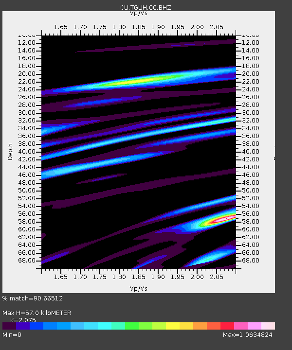
| Estimated Moho Depth: |
57.0 km |
| Estimated Crust Vp/Vs: |
2.08 |
| Assumed Crust Vp: |
6.597 km/s |
| Estimated Crust Vs: |
3.18 km/s |
| Estimated Crust Poisson's Ratio: |
0.35 |
|
| Radial Match: |
90.66512 % |
| Radial Bump: |
400 |
| Transverse Match: |
85.78165 % |
| Transverse Bump: |
400 |
| SOD ConfigId: |
2028011 |
| Insert Time: |
2017-05-22 17:08:01.359 +0000 |
| GWidth: |
2.5 |
| Max Bumps: |
400 |
| Tol: |
0.001 |
|

Signal To Noise
| Channel | StoN | STA | LTA |
| CU:TGUH:00:BHZ:20170508T17:12:39.273987Z | 2.0858035 | 2.6603368E-6 | 1.2754493E-6 |
| CU:TGUH:00:BH1:20170508T17:12:39.273987Z | 2.362512 | 6.900114E-7 | 2.9206683E-7 |
| CU:TGUH:00:BH2:20170508T17:12:39.273987Z | 2.781966 | 1.3544186E-6 | 4.8685666E-7 |
| Arrivals |
| Ps | 9.5 SECOND |
| PpPs | 26 SECOND |
| PsPs/PpSs | 35 SECOND |


