You are here: Home > Network List > TA - USArray Transportable Network (new EarthScope stations) Stations List
> Station D23K Nanushuk River, AK USA > Earthquake Result Viewer
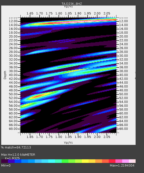
D23K Nanushuk River, AK USA - Earthquake Result Viewer
| Earthquake location: |
Vanuatu Islands |
| Earthquake latitude/longitude: |
-13.1/167.0 |
| Earthquake time(UTC): |
2020/03/18 (078) 03:13:45 GMT |
| Earthquake Depth: |
176 km |
| Earthquake Magnitude: |
6.1 mww |
| Earthquake Catalog/Contributor: |
NEIC PDE/us |
|
| Network: |
TA USArray Transportable Network (new EarthScope stations) |
| Station: |
D23K Nanushuk River, AK USA |
| Lat/Lon: |
68.97 N/150.68 W |
| Elevation: |
406 m |
|
| Distance: |
87.2 deg |
| Az: |
14.078 deg |
| Baz: |
221.02 deg |
| Ray Param: |
0.043129023 |
| Estimated Moho Depth: |
12.0 km |
| Estimated Crust Vp/Vs: |
1.93 |
| Assumed Crust Vp: |
6.221 km/s |
| Estimated Crust Vs: |
3.219 km/s |
| Estimated Crust Poisson's Ratio: |
0.32 |
|
| Radial Match: |
84.72113 % |
| Radial Bump: |
400 |
| Transverse Match: |
73.88369 % |
| Transverse Bump: |
400 |
| SOD ConfigId: |
20906531 |
| Insert Time: |
2020-04-08 12:00:10.553 +0000 |
| GWidth: |
2.5 |
| Max Bumps: |
400 |
| Tol: |
0.001 |
|

Signal To Noise
| Channel | StoN | STA | LTA |
| TA:D23K: :BHZ:20200318T03:25:40.624996Z | 2.8504825 | 1.5060419E-6 | 5.2834633E-7 |
| TA:D23K: :BHN:20200318T03:25:40.624996Z | 1.8494053 | 2.7883144E-7 | 1.5076817E-7 |
| TA:D23K: :BHE:20200318T03:25:40.624996Z | 1.2241414 | 2.2628268E-7 | 1.8485012E-7 |
| Arrivals |
| Ps | 1.8 SECOND |
| PpPs | 5.5 SECOND |
| PsPs/PpSs | 7.4 SECOND |


