You are here: Home > Network List > TA - USArray Transportable Network (new EarthScope stations) Stations List
> Station E18K Tukpahlearik Creek, AK, USA > Earthquake Result Viewer
E18K Tukpahlearik Creek, AK, USA - Earthquake Result Viewer

| Earthquake location: |
Vanuatu Islands |
| Earthquake latitude/longitude: |
-13.1/167.0 |
| Earthquake time(UTC): |
2020/03/18 (078) 03:13:45 GMT |
| Earthquake Depth: |
176 km |
| Earthquake Magnitude: |
6.1 mww |
| Earthquake Catalog/Contributor: |
NEIC PDE/us |
|
| Network: |
TA USArray Transportable Network (new EarthScope stations) |
| Station: |
E18K Tukpahlearik Creek, AK, USA |
| Lat/Lon: |
67.42 N/160.60 W |
| Elevation: |
297 m |
|
| Distance: |
83.7 deg |
| Az: |
12.004 deg |
| Baz: |
211.648 deg |
| Ray Param: |
0.045577742 |
| Estimated Moho Depth: |
16.0 km |
| Estimated Crust Vp/Vs: |
1.89 |
| Assumed Crust Vp: |
6.276 km/s |
| Estimated Crust Vs: |
3.312 km/s |
| Estimated Crust Poisson's Ratio: |
0.31 |
|
| Radial Match: |
80.81926 % |
| Radial Bump: |
400 |
| Transverse Match: |
76.07696 % |
| Transverse Bump: |
400 |
| SOD ConfigId: |
20906531 |
| Insert Time: |
2020-04-08 12:00:16.872 +0000 |
| GWidth: |
2.5 |
| Max Bumps: |
400 |
| Tol: |
0.001 |
|
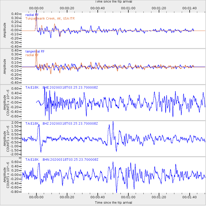
Signal To Noise
| Channel | StoN | STA | LTA |
| TA:E18K: :BHZ:20200318T03:25:23.700008Z | 2.6316874 | 9.384192E-7 | 3.565846E-7 |
| TA:E18K: :BHN:20200318T03:25:23.700008Z | 1.7173709 | 2.894704E-7 | 1.6855438E-7 |
| TA:E18K: :BHE:20200318T03:25:23.700008Z | 1.1729231 | 2.2289613E-7 | 1.9003474E-7 |
| Arrivals |
| Ps | 2.3 SECOND |
| PpPs | 7.2 SECOND |
| PsPs/PpSs | 9.6 SECOND |


