You are here: Home > Network List > TA - USArray Transportable Network (new EarthScope stations) Stations List
> Station G21K Allakaket, AK, USA > Earthquake Result Viewer
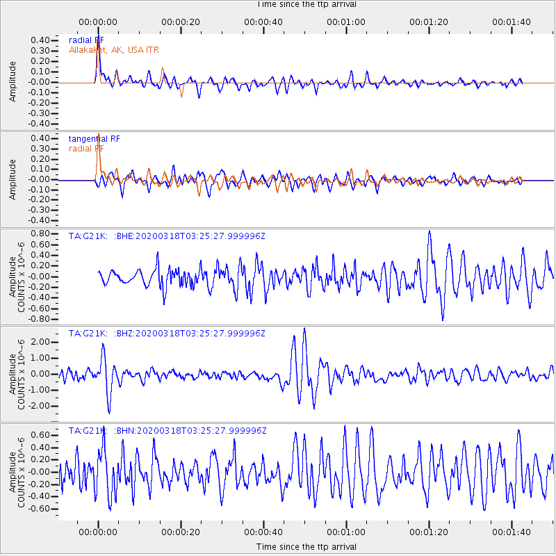
G21K Allakaket, AK, USA - Earthquake Result Viewer
*The percent match for this event was below the threshold and hence no stack was calculated.
| Earthquake location: |
Vanuatu Islands |
| Earthquake latitude/longitude: |
-13.1/167.0 |
| Earthquake time(UTC): |
2020/03/18 (078) 03:13:45 GMT |
| Earthquake Depth: |
176 km |
| Earthquake Magnitude: |
6.1 mww |
| Earthquake Catalog/Contributor: |
NEIC PDE/us |
|
| Network: |
TA USArray Transportable Network (new EarthScope stations) |
| Station: |
G21K Allakaket, AK, USA |
| Lat/Lon: |
66.52 N/153.51 W |
| Elevation: |
446 m |
|
| Distance: |
84.6 deg |
| Az: |
14.825 deg |
| Baz: |
218.462 deg |
| Ray Param: |
$rayparam |
*The percent match for this event was below the threshold and hence was not used in the summary stack. |
|
| Radial Match: |
76.845825 % |
| Radial Bump: |
400 |
| Transverse Match: |
75.48633 % |
| Transverse Bump: |
400 |
| SOD ConfigId: |
20906531 |
| Insert Time: |
2020-04-08 12:00:58.433 +0000 |
| GWidth: |
2.5 |
| Max Bumps: |
400 |
| Tol: |
0.001 |
|
Signal To Noise
| Channel | StoN | STA | LTA |
| TA:G21K: :BHZ:20200318T03:25:27.999996Z | 2.9696348 | 1.0960578E-6 | 3.690884E-7 |
| TA:G21K: :BHN:20200318T03:25:27.999996Z | 3.0891914 | 3.812537E-7 | 1.2341538E-7 |
| TA:G21K: :BHE:20200318T03:25:27.999996Z | 1.5037692 | 2.1274361E-7 | 1.4147358E-7 |
| Arrivals |
| Ps | |
| PpPs | |
| PsPs/PpSs | |


