You are here: Home > Network List > TA - USArray Transportable Network (new EarthScope stations) Stations List
> Station H31M Peel River, Yukon, CAN > Earthquake Result Viewer
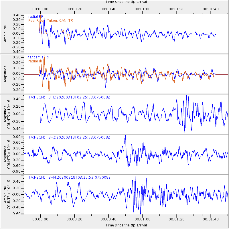
H31M Peel River, Yukon, CAN - Earthquake Result Viewer
*The percent match for this event was below the threshold and hence no stack was calculated.
| Earthquake location: |
Vanuatu Islands |
| Earthquake latitude/longitude: |
-13.1/167.0 |
| Earthquake time(UTC): |
2020/03/18 (078) 03:13:45 GMT |
| Earthquake Depth: |
176 km |
| Earthquake Magnitude: |
6.1 mww |
| Earthquake Catalog/Contributor: |
NEIC PDE/us |
|
| Network: |
TA USArray Transportable Network (new EarthScope stations) |
| Station: |
H31M Peel River, Yukon, CAN |
| Lat/Lon: |
65.81 N/134.34 W |
| Elevation: |
642 m |
|
| Distance: |
89.8 deg |
| Az: |
20.603 deg |
| Baz: |
236.281 deg |
| Ray Param: |
$rayparam |
*The percent match for this event was below the threshold and hence was not used in the summary stack. |
|
| Radial Match: |
52.89645 % |
| Radial Bump: |
400 |
| Transverse Match: |
53.164665 % |
| Transverse Bump: |
400 |
| SOD ConfigId: |
20906531 |
| Insert Time: |
2020-04-08 12:01:18.531 +0000 |
| GWidth: |
2.5 |
| Max Bumps: |
400 |
| Tol: |
0.001 |
|
Signal To Noise
| Channel | StoN | STA | LTA |
| TA:H31M: :BHZ:20200318T03:25:53.075008Z | 1.810927 | 2.679349E-7 | 1.4795457E-7 |
| TA:H31M: :BHN:20200318T03:25:53.075008Z | 1.5105222 | 9.963924E-8 | 6.5963434E-8 |
| TA:H31M: :BHE:20200318T03:25:53.075008Z | 0.76065314 | 1.0096705E-7 | 1.3273731E-7 |
| Arrivals |
| Ps | |
| PpPs | |
| PsPs/PpSs | |


