You are here: Home > Network List > GS - US Geological Survey Networks Stations List
> Station OK031 S. Brethren Rd., Cushing, OK, USA > Earthquake Result Viewer
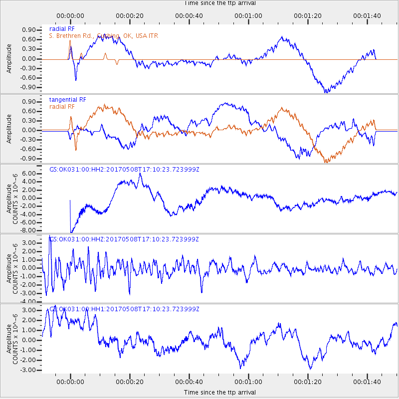
OK031 S. Brethren Rd., Cushing, OK, USA - Earthquake Result Viewer
*The percent match for this event was below the threshold and hence no stack was calculated.
| Earthquake location: |
Andreanof Islands, Aleutian Is. |
| Earthquake latitude/longitude: |
51.4/-178.6 |
| Earthquake time(UTC): |
2017/05/08 (128) 17:01:00 GMT |
| Earthquake Depth: |
1.6 km |
| Earthquake Magnitude: |
6.6 Mi |
| Earthquake Catalog/Contributor: |
NEIC PDE/pt |
|
| Network: |
GS US Geological Survey Networks |
| Station: |
OK031 S. Brethren Rd., Cushing, OK, USA |
| Lat/Lon: |
35.95 N/96.84 W |
| Elevation: |
290 m |
|
| Distance: |
58.1 deg |
| Az: |
71.06 deg |
| Baz: |
313.09 deg |
| Ray Param: |
$rayparam |
*The percent match for this event was below the threshold and hence was not used in the summary stack. |
|
| Radial Match: |
48.255135 % |
| Radial Bump: |
400 |
| Transverse Match: |
20.644445 % |
| Transverse Bump: |
400 |
| SOD ConfigId: |
2028011 |
| Insert Time: |
2017-05-22 17:09:04.983 +0000 |
| GWidth: |
2.5 |
| Max Bumps: |
400 |
| Tol: |
0.001 |
|
Signal To Noise
| Channel | StoN | STA | LTA |
| GS:OK031:00:HHZ:20170508T17:10:23.723999Z | 0.8587698 | 9.2399495E-7 | 1.0759518E-6 |
| GS:OK031:00:HH1:20170508T17:10:23.723999Z | 1.6302791 | 3.7397685E-6 | 2.2939437E-6 |
| GS:OK031:00:HH2:20170508T17:10:23.723999Z | 0.5996151 | 2.3205296E-6 | 3.8700323E-6 |
| Arrivals |
| Ps | |
| PpPs | |
| PsPs/PpSs | |


