You are here: Home > Network List > TS - TERRAscope (Southern California Seismic Network) Stations List
> Station PFO Pinon Flat, California, USA > Earthquake Result Viewer
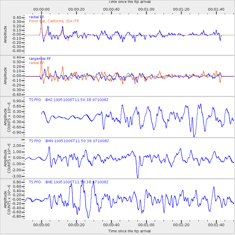
PFO Pinon Flat, California, USA - Earthquake Result Viewer
*The percent match for this event was below the threshold and hence no stack was calculated.
| Earthquake location: |
Tonga Islands |
| Earthquake latitude/longitude: |
-20.0/-175.9 |
| Earthquake time(UTC): |
1995/10/06 (279) 11:39:36 GMT |
| Earthquake Depth: |
209 km |
| Earthquake Magnitude: |
5.7 MB, 6.4 UNKNOWN, 6.3 MW |
| Earthquake Catalog/Contributor: |
WHDF/NEIC |
|
| Network: |
TS TERRAscope (Southern California Seismic Network) |
| Station: |
PFO Pinon Flat, California, USA |
| Lat/Lon: |
33.61 N/116.46 W |
| Elevation: |
1280 m |
|
| Distance: |
77.8 deg |
| Az: |
47.341 deg |
| Baz: |
235.955 deg |
| Ray Param: |
$rayparam |
*The percent match for this event was below the threshold and hence was not used in the summary stack. |
|
| Radial Match: |
71.71619 % |
| Radial Bump: |
400 |
| Transverse Match: |
53.95461 % |
| Transverse Bump: |
400 |
| SOD ConfigId: |
4480 |
| Insert Time: |
2010-02-26 14:44:25.937 +0000 |
| GWidth: |
2.5 |
| Max Bumps: |
400 |
| Tol: |
0.001 |
|
Signal To Noise
| Channel | StoN | STA | LTA |
| TS:PFO: :BHN:19951006T11:50:38.971008Z | 3.2318504 | 7.30579E-7 | 2.2605596E-7 |
| TS:PFO: :BHE:19951006T11:50:38.971008Z | 0.40170643 | 9.555107E-8 | 2.3786293E-7 |
| TS:PFO: :BHZ:19951006T11:50:38.971008Z | 1.4617257 | 1.7708996E-7 | 1.2115129E-7 |
| Arrivals |
| Ps | |
| PpPs | |
| PsPs/PpSs | |


