You are here: Home > Network List > TA - USArray Transportable Network (new EarthScope stations) Stations List
> Station P18K Big Mountain, AK, USA > Earthquake Result Viewer
P18K Big Mountain, AK, USA - Earthquake Result Viewer
| Earthquake location: |
Vanuatu Islands |
| Earthquake latitude/longitude: |
-13.1/167.0 |
| Earthquake time(UTC): |
2020/03/18 (078) 03:13:45 GMT |
| Earthquake Depth: |
176 km |
| Earthquake Magnitude: |
6.1 mww |
| Earthquake Catalog/Contributor: |
NEIC PDE/us |
|
| Network: |
TA USArray Transportable Network (new EarthScope stations) |
| Station: |
P18K Big Mountain, AK, USA |
| Lat/Lon: |
59.39 N/155.23 W |
| Elevation: |
680 m |
|
| Distance: |
78.5 deg |
| Az: |
18.644 deg |
| Baz: |
217.49 deg |
| Ray Param: |
0.049199093 |
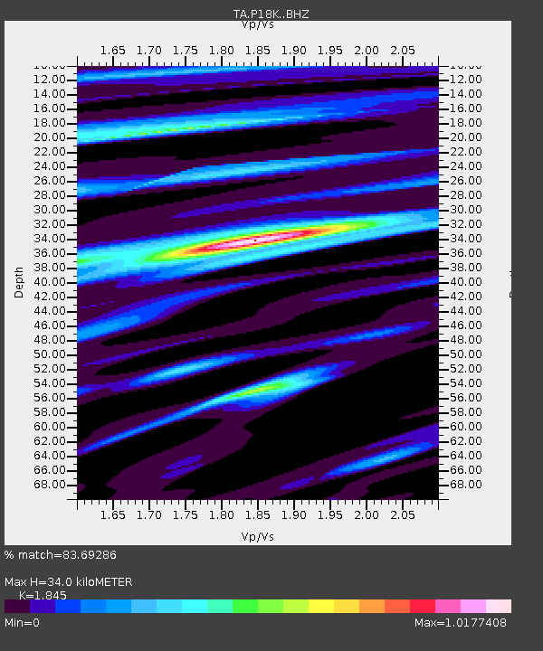
| Estimated Moho Depth: |
34.0 km |
| Estimated Crust Vp/Vs: |
1.85 |
| Assumed Crust Vp: |
6.438 km/s |
| Estimated Crust Vs: |
3.49 km/s |
| Estimated Crust Poisson's Ratio: |
0.29 |
|
| Radial Match: |
83.69286 % |
| Radial Bump: |
400 |
| Transverse Match: |
76.10583 % |
| Transverse Bump: |
400 |
| SOD ConfigId: |
20906531 |
| Insert Time: |
2020-04-08 12:02:26.961 +0000 |
| GWidth: |
2.5 |
| Max Bumps: |
400 |
| Tol: |
0.001 |
|

Signal To Noise
| Channel | StoN | STA | LTA |
| TA:P18K: :BHZ:20200318T03:24:56.02502Z | 6.422121 | 1.0023375E-6 | 1.5607576E-7 |
| TA:P18K: :BHN:20200318T03:24:56.02502Z | 1.8091446 | 3.400948E-7 | 1.8798652E-7 |
| TA:P18K: :BHE:20200318T03:24:56.02502Z | 1.4486334 | 2.186628E-7 | 1.5094419E-7 |
| Arrivals |
| Ps | 4.6 SECOND |
| PpPs | 15 SECOND |
| PsPs/PpSs | 19 SECOND |


