You are here: Home > Network List > TS - TERRAscope (Southern California Seismic Network) Stations List
> Station PFO Pinon Flat, California, USA > Earthquake Result Viewer
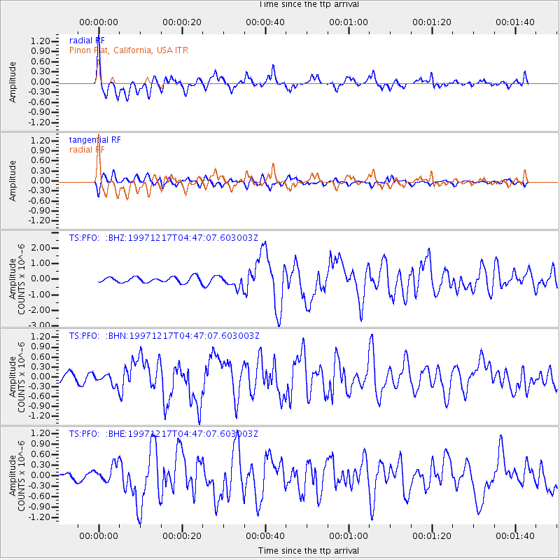
PFO Pinon Flat, California, USA - Earthquake Result Viewer
*The percent match for this event was below the threshold and hence no stack was calculated.
| Earthquake location: |
Rat Islands, Aleutian Islands |
| Earthquake latitude/longitude: |
51.2/178.9 |
| Earthquake time(UTC): |
1997/12/17 (351) 04:38:51 GMT |
| Earthquake Depth: |
20 km |
| Earthquake Magnitude: |
5.8 MB, 6.5 MS, 6.7 UNKNOWN, 6.1 ME |
| Earthquake Catalog/Contributor: |
WHDF/NEIC |
|
| Network: |
TS TERRAscope (Southern California Seismic Network) |
| Station: |
PFO Pinon Flat, California, USA |
| Lat/Lon: |
33.61 N/116.46 W |
| Elevation: |
1280 m |
|
| Distance: |
49.2 deg |
| Az: |
84.751 deg |
| Baz: |
311.327 deg |
| Ray Param: |
$rayparam |
*The percent match for this event was below the threshold and hence was not used in the summary stack. |
|
| Radial Match: |
66.726715 % |
| Radial Bump: |
400 |
| Transverse Match: |
63.75168 % |
| Transverse Bump: |
400 |
| SOD ConfigId: |
4480 |
| Insert Time: |
2010-02-26 14:44:26.375 +0000 |
| GWidth: |
2.5 |
| Max Bumps: |
400 |
| Tol: |
0.001 |
|
Signal To Noise
| Channel | StoN | STA | LTA |
| TS:PFO: :BHN:19971217T04:47:07.603003Z | 0.88833106 | 1.7462463E-7 | 1.9657608E-7 |
| TS:PFO: :BHE:19971217T04:47:07.603003Z | 1.4575406 | 2.5796732E-7 | 1.7698808E-7 |
| TS:PFO: :BHZ:19971217T04:47:07.603003Z | 2.2391274 | 4.0114105E-7 | 1.7915062E-7 |
| Arrivals |
| Ps | |
| PpPs | |
| PsPs/PpSs | |


