You are here: Home > Network List > US - United States National Seismic Network Stations List
> Station WUAZ Wupatki, Arizona, USA > Earthquake Result Viewer
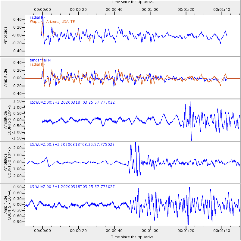
WUAZ Wupatki, Arizona, USA - Earthquake Result Viewer
*The percent match for this event was below the threshold and hence no stack was calculated.
| Earthquake location: |
Vanuatu Islands |
| Earthquake latitude/longitude: |
-13.1/167.0 |
| Earthquake time(UTC): |
2020/03/18 (078) 03:13:45 GMT |
| Earthquake Depth: |
176 km |
| Earthquake Magnitude: |
6.1 mww |
| Earthquake Catalog/Contributor: |
NEIC PDE/us |
|
| Network: |
US United States National Seismic Network |
| Station: |
WUAZ Wupatki, Arizona, USA |
| Lat/Lon: |
35.52 N/111.37 W |
| Elevation: |
1592 m |
|
| Distance: |
90.8 deg |
| Az: |
53.815 deg |
| Baz: |
254.539 deg |
| Ray Param: |
$rayparam |
*The percent match for this event was below the threshold and hence was not used in the summary stack. |
|
| Radial Match: |
79.3858 % |
| Radial Bump: |
400 |
| Transverse Match: |
83.45013 % |
| Transverse Bump: |
400 |
| SOD ConfigId: |
20906531 |
| Insert Time: |
2020-04-08 12:04:12.718 +0000 |
| GWidth: |
2.5 |
| Max Bumps: |
400 |
| Tol: |
0.001 |
|
Signal To Noise
| Channel | StoN | STA | LTA |
| US:WUAZ:00:BHZ:20200318T03:25:57.77502Z | 2.6904213 | 4.0443754E-7 | 1.5032498E-7 |
| US:WUAZ:00:BH1:20200318T03:25:57.77502Z | 0.5677497 | 5.96679E-8 | 1.0509543E-7 |
| US:WUAZ:00:BH2:20200318T03:25:57.77502Z | 2.1350696 | 2.3499784E-7 | 1.1006566E-7 |
| Arrivals |
| Ps | |
| PpPs | |
| PsPs/PpSs | |


