You are here: Home > Network List > UW - Pacific Northwest Regional Seismic Network Stations List
> Station BERY Pilchuck Tree Farm, Arlington, WA, USA > Earthquake Result Viewer
BERY Pilchuck Tree Farm, Arlington, WA, USA - Earthquake Result Viewer
| Earthquake location: |
Vanuatu Islands |
| Earthquake latitude/longitude: |
-13.1/167.0 |
| Earthquake time(UTC): |
2020/03/18 (078) 03:13:45 GMT |
| Earthquake Depth: |
176 km |
| Earthquake Magnitude: |
6.1 mww |
| Earthquake Catalog/Contributor: |
NEIC PDE/us |
|
| Network: |
UW Pacific Northwest Regional Seismic Network |
| Station: |
BERY Pilchuck Tree Farm, Arlington, WA, USA |
| Lat/Lon: |
48.26 N/122.10 W |
| Elevation: |
150 m |
|
| Distance: |
87.4 deg |
| Az: |
39.195 deg |
| Baz: |
247.124 deg |
| Ray Param: |
0.042947344 |
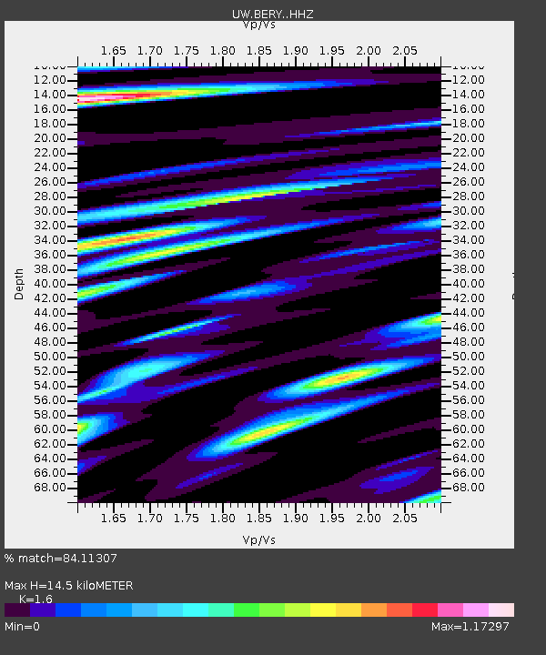
| Estimated Moho Depth: |
14.5 km |
| Estimated Crust Vp/Vs: |
1.60 |
| Assumed Crust Vp: |
6.566 km/s |
| Estimated Crust Vs: |
4.104 km/s |
| Estimated Crust Poisson's Ratio: |
0.18 |
|
| Radial Match: |
84.11307 % |
| Radial Bump: |
400 |
| Transverse Match: |
60.567627 % |
| Transverse Bump: |
400 |
| SOD ConfigId: |
20906531 |
| Insert Time: |
2020-04-08 12:05:00.901 +0000 |
| GWidth: |
2.5 |
| Max Bumps: |
400 |
| Tol: |
0.001 |
|

Signal To Noise
| Channel | StoN | STA | LTA |
| UW:BERY: :HHZ:20200318T03:25:41.799983Z | 5.0723963 | 6.734187E-7 | 1.3276146E-7 |
| UW:BERY: :HHN:20200318T03:25:41.799983Z | 0.59639144 | 7.7575194E-8 | 1.300743E-7 |
| UW:BERY: :HHE:20200318T03:25:41.799983Z | 1.8933929 | 2.6282035E-7 | 1.388092E-7 |
| Arrivals |
| Ps | 1.4 SECOND |
| PpPs | 5.6 SECOND |
| PsPs/PpSs | 7.0 SECOND |


