You are here: Home > Network List > TA - USArray Transportable Network (new EarthScope stations) Stations List
> Station D23K Nanushuk River, AK USA > Earthquake Result Viewer
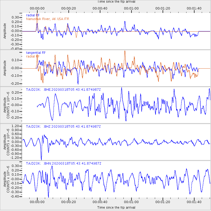
D23K Nanushuk River, AK USA - Earthquake Result Viewer
*The percent match for this event was below the threshold and hence no stack was calculated.
| Earthquake location: |
Santa Cruz Islands Region |
| Earthquake latitude/longitude: |
-11.0/164.4 |
| Earthquake time(UTC): |
2020/03/18 (078) 05:31:33 GMT |
| Earthquake Depth: |
10 km |
| Earthquake Magnitude: |
5.5 Mww |
| Earthquake Catalog/Contributor: |
NEIC PDE/us |
|
| Network: |
TA USArray Transportable Network (new EarthScope stations) |
| Station: |
D23K Nanushuk River, AK USA |
| Lat/Lon: |
68.97 N/150.68 W |
| Elevation: |
406 m |
|
| Distance: |
85.8 deg |
| Az: |
14.804 deg |
| Baz: |
224.011 deg |
| Ray Param: |
$rayparam |
*The percent match for this event was below the threshold and hence was not used in the summary stack. |
|
| Radial Match: |
68.92425 % |
| Radial Bump: |
400 |
| Transverse Match: |
62.75649 % |
| Transverse Bump: |
400 |
| SOD ConfigId: |
20906531 |
| Insert Time: |
2020-04-08 12:17:12.908 +0000 |
| GWidth: |
2.5 |
| Max Bumps: |
400 |
| Tol: |
0.001 |
|
Signal To Noise
| Channel | StoN | STA | LTA |
| TA:D23K: :BHZ:20200318T05:43:41.874987Z | 3.130886 | 4.568461E-7 | 1.4591592E-7 |
| TA:D23K: :BHN:20200318T05:43:41.874987Z | 1.482877 | 1.4943883E-7 | 1.0077628E-7 |
| TA:D23K: :BHE:20200318T05:43:41.874987Z | 0.7918554 | 7.0079224E-8 | 8.850003E-8 |
| Arrivals |
| Ps | |
| PpPs | |
| PsPs/PpSs | |


