You are here: Home > Network List > TA - USArray Transportable Network (new EarthScope stations) Stations List
> Station F20K Avaraart Lake, AK, USA > Earthquake Result Viewer
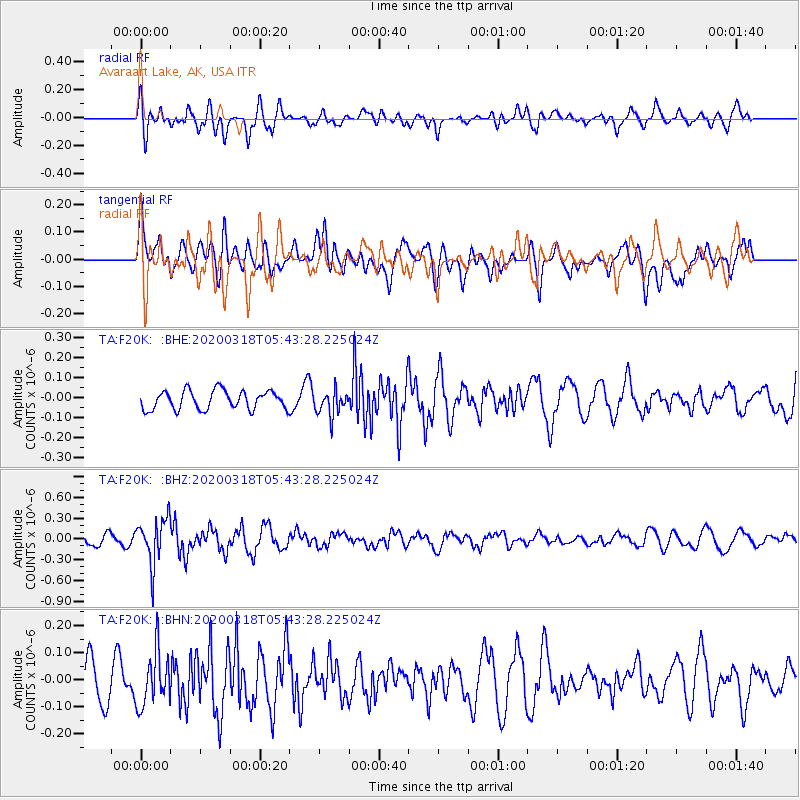
F20K Avaraart Lake, AK, USA - Earthquake Result Viewer
*The percent match for this event was below the threshold and hence no stack was calculated.
| Earthquake location: |
Santa Cruz Islands Region |
| Earthquake latitude/longitude: |
-11.0/164.4 |
| Earthquake time(UTC): |
2020/03/18 (078) 05:31:33 GMT |
| Earthquake Depth: |
10 km |
| Earthquake Magnitude: |
5.5 Mww |
| Earthquake Catalog/Contributor: |
NEIC PDE/us |
|
| Network: |
TA USArray Transportable Network (new EarthScope stations) |
| Station: |
F20K Avaraart Lake, AK, USA |
| Lat/Lon: |
67.05 N/155.73 W |
| Elevation: |
136 m |
|
| Distance: |
83.1 deg |
| Az: |
14.664 deg |
| Baz: |
219.323 deg |
| Ray Param: |
$rayparam |
*The percent match for this event was below the threshold and hence was not used in the summary stack. |
|
| Radial Match: |
59.828987 % |
| Radial Bump: |
400 |
| Transverse Match: |
49.205566 % |
| Transverse Bump: |
400 |
| SOD ConfigId: |
20906531 |
| Insert Time: |
2020-04-08 12:17:38.861 +0000 |
| GWidth: |
2.5 |
| Max Bumps: |
400 |
| Tol: |
0.001 |
|
Signal To Noise
| Channel | StoN | STA | LTA |
| TA:F20K: :BHZ:20200318T05:43:28.225024Z | 4.8838296 | 3.3007439E-7 | 6.7585155E-8 |
| TA:F20K: :BHN:20200318T05:43:28.225024Z | 1.3878778 | 9.9574606E-8 | 7.1745944E-8 |
| TA:F20K: :BHE:20200318T05:43:28.225024Z | 1.3391293 | 6.223588E-8 | 4.647488E-8 |
| Arrivals |
| Ps | |
| PpPs | |
| PsPs/PpSs | |


