You are here: Home > Network List > TA - USArray Transportable Network (new EarthScope stations) Stations List
> Station G21K Allakaket, AK, USA > Earthquake Result Viewer
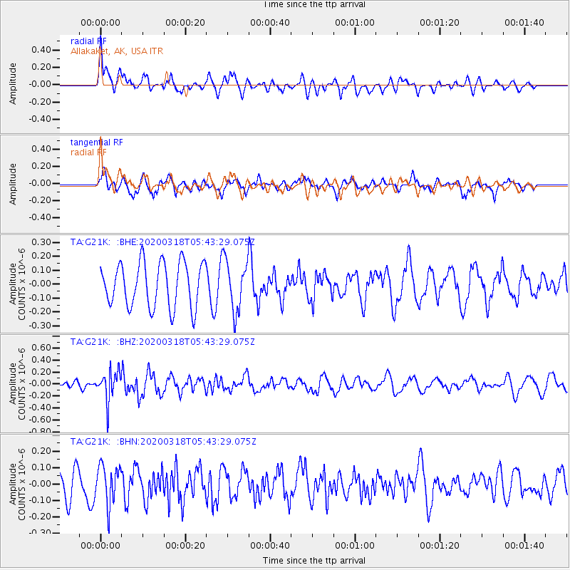
G21K Allakaket, AK, USA - Earthquake Result Viewer
*The percent match for this event was below the threshold and hence no stack was calculated.
| Earthquake location: |
Santa Cruz Islands Region |
| Earthquake latitude/longitude: |
-11.0/164.4 |
| Earthquake time(UTC): |
2020/03/18 (078) 05:31:33 GMT |
| Earthquake Depth: |
10 km |
| Earthquake Magnitude: |
5.5 Mww |
| Earthquake Catalog/Contributor: |
NEIC PDE/us |
|
| Network: |
TA USArray Transportable Network (new EarthScope stations) |
| Station: |
G21K Allakaket, AK, USA |
| Lat/Lon: |
66.52 N/153.51 W |
| Elevation: |
446 m |
|
| Distance: |
83.2 deg |
| Az: |
15.688 deg |
| Baz: |
221.483 deg |
| Ray Param: |
$rayparam |
*The percent match for this event was below the threshold and hence was not used in the summary stack. |
|
| Radial Match: |
38.548473 % |
| Radial Bump: |
400 |
| Transverse Match: |
63.894344 % |
| Transverse Bump: |
400 |
| SOD ConfigId: |
20906531 |
| Insert Time: |
2020-04-08 12:17:55.487 +0000 |
| GWidth: |
2.5 |
| Max Bumps: |
400 |
| Tol: |
0.001 |
|
Signal To Noise
| Channel | StoN | STA | LTA |
| TA:G21K: :BHZ:20200318T05:43:29.075Z | 2.914222 | 2.445728E-7 | 8.392387E-8 |
| TA:G21K: :BHN:20200318T05:43:29.075Z | 1.489613 | 1.2013717E-7 | 8.0649926E-8 |
| TA:G21K: :BHE:20200318T05:43:29.075Z | 1.1205249 | 1.7952274E-7 | 1.6021308E-7 |
| Arrivals |
| Ps | |
| PpPs | |
| PsPs/PpSs | |


