You are here: Home > Network List > TA - USArray Transportable Network (new EarthScope stations) Stations List
> Station A19K Wainwright, AK, USA > Earthquake Result Viewer
A19K Wainwright, AK, USA - Earthquake Result Viewer
| Earthquake location: |
Utah |
| Earthquake latitude/longitude: |
40.8/-112.1 |
| Earthquake time(UTC): |
2020/03/18 (078) 13:09:31 GMT |
| Earthquake Depth: |
12 km |
| Earthquake Magnitude: |
5.7 mw |
| Earthquake Catalog/Contributor: |
NEIC PDE/uu |
|
| Network: |
TA USArray Transportable Network (new EarthScope stations) |
| Station: |
A19K Wainwright, AK, USA |
| Lat/Lon: |
70.20 N/161.07 W |
| Elevation: |
24 m |
|
| Distance: |
38.6 deg |
| Az: |
335.682 deg |
| Baz: |
113.32 deg |
| Ray Param: |
0.07547434 |
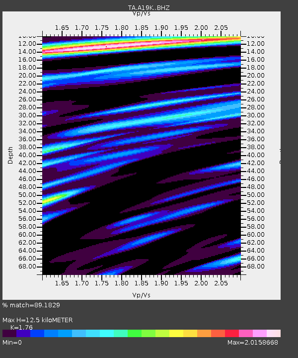
| Estimated Moho Depth: |
12.5 km |
| Estimated Crust Vp/Vs: |
1.76 |
| Assumed Crust Vp: |
5.989 km/s |
| Estimated Crust Vs: |
3.403 km/s |
| Estimated Crust Poisson's Ratio: |
0.26 |
|
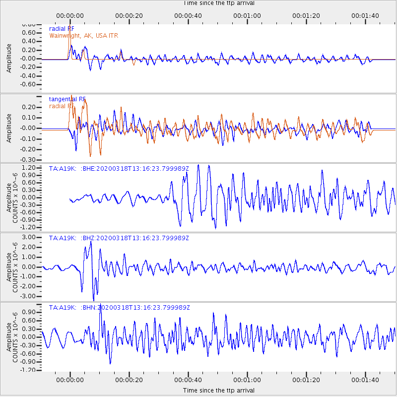
| Radial Match: |
89.1829 % |
| Radial Bump: |
400 |
| Transverse Match: |
74.52703 % |
| Transverse Bump: |
400 |
| SOD ConfigId: |
20906531 |
| Insert Time: |
2020-04-08 12:30:38.054 +0000 |
| GWidth: |
2.5 |
| Max Bumps: |
400 |
| Tol: |
0.001 |
|
Signal To Noise
| Channel | StoN | STA | LTA |
| TA:A19K: :BHZ:20200318T13:16:23.799989Z | 6.6873274 | 8.1264903E-7 | 1.2152076E-7 |
| TA:A19K: :BHN:20200318T13:16:23.799989Z | 0.8040364 | 1.4769438E-7 | 1.8369117E-7 |
| TA:A19K: :BHE:20200318T13:16:23.799989Z | 1.8986806 | 2.4472794E-7 | 1.2889367E-7 |
| Arrivals |
| Ps | 1.7 SECOND |
| PpPs | 5.4 SECOND |
| PsPs/PpSs | 7.1 SECOND |


