You are here: Home > Network List > TS - TERRAscope (Southern California Seismic Network) Stations List
> Station PFO Pinon Flat, California, USA > Earthquake Result Viewer
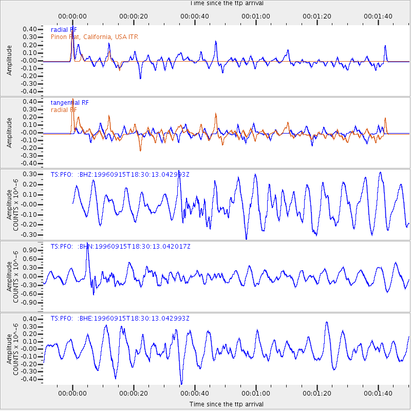
PFO Pinon Flat, California, USA - Earthquake Result Viewer
*The percent match for this event was below the threshold and hence no stack was calculated.
| Earthquake location: |
Solomon Islands |
| Earthquake latitude/longitude: |
-6.5/154.8 |
| Earthquake time(UTC): |
1996/09/15 (259) 18:17:38 GMT |
| Earthquake Depth: |
50 km |
| Earthquake Magnitude: |
5.7 MB, 5.8 MS, 5.9 UNKNOWN, 5.9 MW |
| Earthquake Catalog/Contributor: |
WHDF/NEIC |
|
| Network: |
TS TERRAscope (Southern California Seismic Network) |
| Station: |
PFO Pinon Flat, California, USA |
| Lat/Lon: |
33.61 N/116.46 W |
| Elevation: |
1280 m |
|
| Distance: |
92.5 deg |
| Az: |
56.63 deg |
| Baz: |
263.929 deg |
| Ray Param: |
$rayparam |
*The percent match for this event was below the threshold and hence was not used in the summary stack. |
|
| Radial Match: |
58.28386 % |
| Radial Bump: |
400 |
| Transverse Match: |
48.75727 % |
| Transverse Bump: |
302 |
| SOD ConfigId: |
4480 |
| Insert Time: |
2010-02-26 14:44:31.960 +0000 |
| GWidth: |
2.5 |
| Max Bumps: |
400 |
| Tol: |
0.001 |
|
Signal To Noise
| Channel | StoN | STA | LTA |
| TS:PFO: :BHN:19960915T18:30:13.042017Z | 2.5790222 | 3.0733528E-7 | 1.1916737E-7 |
| TS:PFO: :BHE:19960915T18:30:13.042993Z | 0.94907135 | 9.324652E-8 | 9.8250275E-8 |
| TS:PFO: :BHZ:19960915T18:30:13.042993Z | 1.0940597 | 1.1349899E-7 | 1.0374114E-7 |
| Arrivals |
| Ps | |
| PpPs | |
| PsPs/PpSs | |


