You are here: Home > Network List > TA - USArray Transportable Network (new EarthScope stations) Stations List
> Station D23K Nanushuk River, AK USA > Earthquake Result Viewer
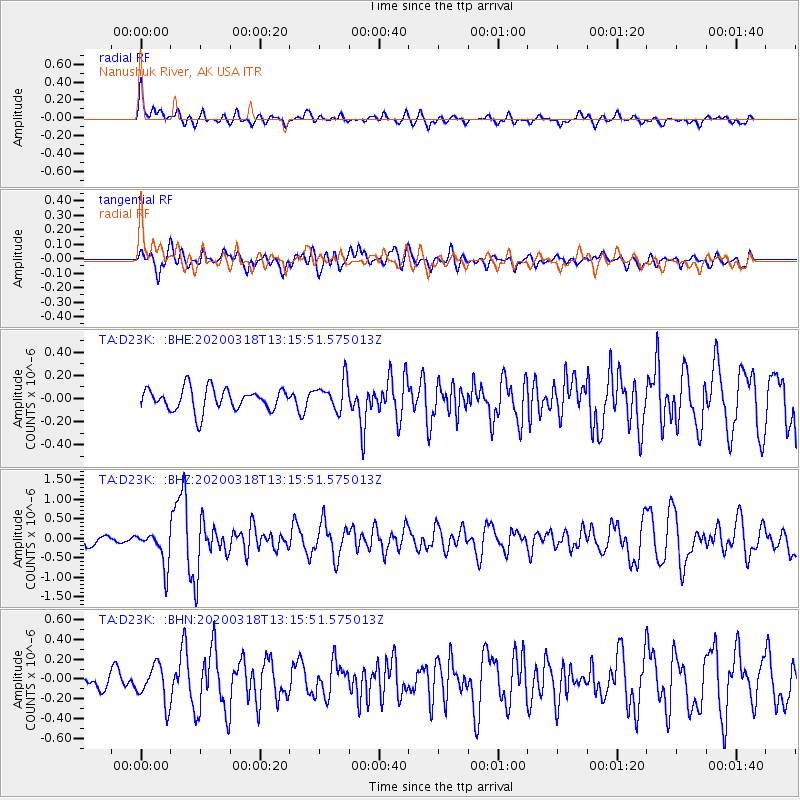
D23K Nanushuk River, AK USA - Earthquake Result Viewer
*The percent match for this event was below the threshold and hence no stack was calculated.
| Earthquake location: |
Utah |
| Earthquake latitude/longitude: |
40.8/-112.1 |
| Earthquake time(UTC): |
2020/03/18 (078) 13:09:31 GMT |
| Earthquake Depth: |
12 km |
| Earthquake Magnitude: |
5.7 mw |
| Earthquake Catalog/Contributor: |
NEIC PDE/uu |
|
| Network: |
TA USArray Transportable Network (new EarthScope stations) |
| Station: |
D23K Nanushuk River, AK USA |
| Lat/Lon: |
68.97 N/150.68 W |
| Elevation: |
406 m |
|
| Distance: |
34.8 deg |
| Az: |
336.778 deg |
| Baz: |
123.933 deg |
| Ray Param: |
$rayparam |
*The percent match for this event was below the threshold and hence was not used in the summary stack. |
|
| Radial Match: |
63.59932 % |
| Radial Bump: |
400 |
| Transverse Match: |
75.636734 % |
| Transverse Bump: |
400 |
| SOD ConfigId: |
20906531 |
| Insert Time: |
2020-04-08 12:31:03.258 +0000 |
| GWidth: |
2.5 |
| Max Bumps: |
400 |
| Tol: |
0.001 |
|
Signal To Noise
| Channel | StoN | STA | LTA |
| TA:D23K: :BHZ:20200318T13:15:51.575013Z | 3.4482992 | 4.579593E-7 | 1.3280729E-7 |
| TA:D23K: :BHN:20200318T13:15:51.575013Z | 2.0751352 | 1.9217435E-7 | 9.260812E-8 |
| TA:D23K: :BHE:20200318T13:15:51.575013Z | 1.3607241 | 1.3097312E-7 | 9.625252E-8 |
| Arrivals |
| Ps | |
| PpPs | |
| PsPs/PpSs | |


