You are here: Home > Network List > TA - USArray Transportable Network (new EarthScope stations) Stations List
> Station F15K North Star Ditch, AK, USA > Earthquake Result Viewer
F15K North Star Ditch, AK, USA - Earthquake Result Viewer
| Earthquake location: |
Utah |
| Earthquake latitude/longitude: |
40.8/-112.1 |
| Earthquake time(UTC): |
2020/03/18 (078) 13:09:31 GMT |
| Earthquake Depth: |
12 km |
| Earthquake Magnitude: |
5.7 mw |
| Earthquake Catalog/Contributor: |
NEIC PDE/uu |
|
| Network: |
TA USArray Transportable Network (new EarthScope stations) |
| Station: |
F15K North Star Ditch, AK, USA |
| Lat/Lon: |
65.71 N/164.65 W |
| Elevation: |
388 m |
|
| Distance: |
38.5 deg |
| Az: |
328.119 deg |
| Baz: |
104.086 deg |
| Ray Param: |
0.075570874 |
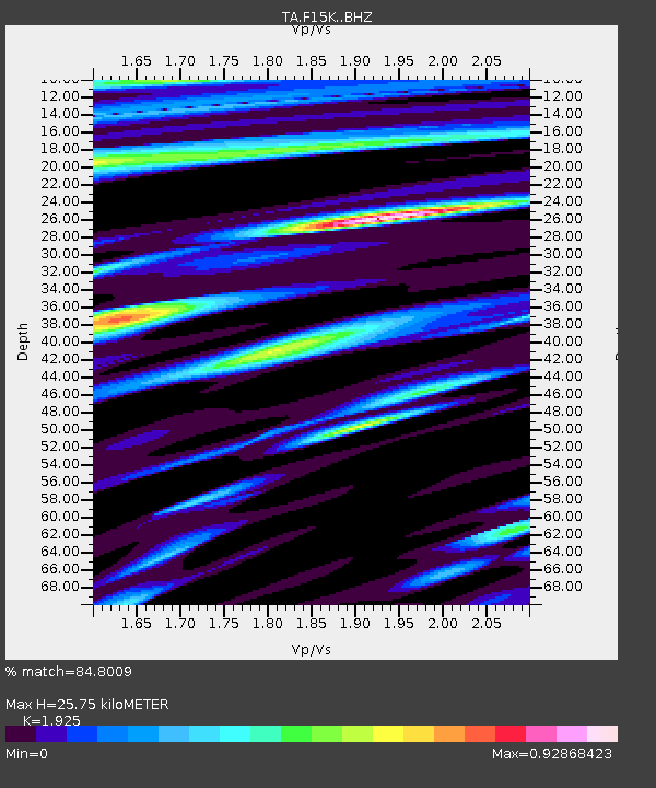
| Estimated Moho Depth: |
25.75 km |
| Estimated Crust Vp/Vs: |
1.92 |
| Assumed Crust Vp: |
6.276 km/s |
| Estimated Crust Vs: |
3.26 km/s |
| Estimated Crust Poisson's Ratio: |
0.32 |
|
| Radial Match: |
84.8009 % |
| Radial Bump: |
400 |
| Transverse Match: |
68.39386 % |
| Transverse Bump: |
400 |
| SOD ConfigId: |
20906531 |
| Insert Time: |
2020-04-08 12:31:26.043 +0000 |
| GWidth: |
2.5 |
| Max Bumps: |
400 |
| Tol: |
0.001 |
|

Signal To Noise
| Channel | StoN | STA | LTA |
| TA:F15K: :BHZ:20200318T13:16:22.375001Z | 7.6045737 | 6.8286647E-7 | 8.9796806E-8 |
| TA:F15K: :BHN:20200318T13:16:22.375001Z | 1.9348495 | 1.8534008E-7 | 9.579044E-8 |
| TA:F15K: :BHE:20200318T13:16:22.375001Z | 6.3043647 | 4.2418887E-7 | 6.728495E-8 |
| Arrivals |
| Ps | 4.0 SECOND |
| PpPs | 11 SECOND |
| PsPs/PpSs | 15 SECOND |


