You are here: Home > Network List > TA - USArray Transportable Network (new EarthScope stations) Stations List
> Station F21K Alatna River, AK, USA > Earthquake Result Viewer
F21K Alatna River, AK, USA - Earthquake Result Viewer
| Earthquake location: |
Utah |
| Earthquake latitude/longitude: |
40.8/-112.1 |
| Earthquake time(UTC): |
2020/03/18 (078) 13:09:31 GMT |
| Earthquake Depth: |
12 km |
| Earthquake Magnitude: |
5.7 mw |
| Earthquake Catalog/Contributor: |
NEIC PDE/uu |
|
| Network: |
TA USArray Transportable Network (new EarthScope stations) |
| Station: |
F21K Alatna River, AK, USA |
| Lat/Lon: |
67.22 N/153.48 W |
| Elevation: |
597 m |
|
| Distance: |
34.8 deg |
| Az: |
333.202 deg |
| Baz: |
118.399 deg |
| Ray Param: |
0.077541195 |
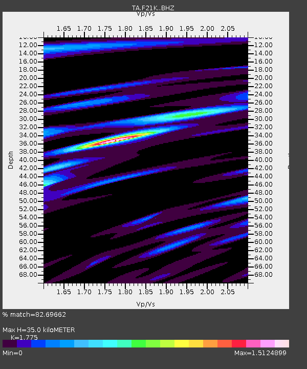
| Estimated Moho Depth: |
35.0 km |
| Estimated Crust Vp/Vs: |
1.77 |
| Assumed Crust Vp: |
6.455 km/s |
| Estimated Crust Vs: |
3.637 km/s |
| Estimated Crust Poisson's Ratio: |
0.27 |
|
| Radial Match: |
82.69662 % |
| Radial Bump: |
400 |
| Transverse Match: |
81.97711 % |
| Transverse Bump: |
400 |
| SOD ConfigId: |
20906531 |
| Insert Time: |
2020-04-08 12:31:33.910 +0000 |
| GWidth: |
2.5 |
| Max Bumps: |
400 |
| Tol: |
0.001 |
|

Signal To Noise
| Channel | StoN | STA | LTA |
| TA:F21K: :BHZ:20200318T13:15:51.500001Z | 5.53164 | 3.586709E-7 | 6.483988E-8 |
| TA:F21K: :BHN:20200318T13:15:51.500001Z | 1.2968855 | 1.1413843E-7 | 8.800965E-8 |
| TA:F21K: :BHE:20200318T13:15:51.500001Z | 2.678072 | 1.9983608E-7 | 7.4619386E-8 |
| Arrivals |
| Ps | 4.5 SECOND |
| PpPs | 14 SECOND |
| PsPs/PpSs | 18 SECOND |


