You are here: Home > Network List > TA - USArray Transportable Network (new EarthScope stations) Stations List
> Station G15K Niukluk, AK, USA > Earthquake Result Viewer
G15K Niukluk, AK, USA - Earthquake Result Viewer
| Earthquake location: |
Utah |
| Earthquake latitude/longitude: |
40.8/-112.1 |
| Earthquake time(UTC): |
2020/03/18 (078) 13:09:31 GMT |
| Earthquake Depth: |
12 km |
| Earthquake Magnitude: |
5.7 mw |
| Earthquake Catalog/Contributor: |
NEIC PDE/uu |
|
| Network: |
TA USArray Transportable Network (new EarthScope stations) |
| Station: |
G15K Niukluk, AK, USA |
| Lat/Lon: |
64.99 N/164.04 W |
| Elevation: |
249 m |
|
| Distance: |
38.0 deg |
| Az: |
327.095 deg |
| Baz: |
103.836 deg |
| Ray Param: |
0.07578675 |
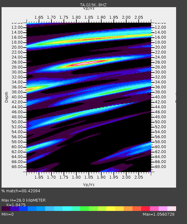
| Estimated Moho Depth: |
26.0 km |
| Estimated Crust Vp/Vs: |
1.85 |
| Assumed Crust Vp: |
6.276 km/s |
| Estimated Crust Vs: |
3.397 km/s |
| Estimated Crust Poisson's Ratio: |
0.29 |
|
| Radial Match: |
88.42094 % |
| Radial Bump: |
295 |
| Transverse Match: |
74.00775 % |
| Transverse Bump: |
400 |
| SOD ConfigId: |
20906531 |
| Insert Time: |
2020-04-08 12:31:40.664 +0000 |
| GWidth: |
2.5 |
| Max Bumps: |
400 |
| Tol: |
0.001 |
|

Signal To Noise
| Channel | StoN | STA | LTA |
| TA:G15K: :BHZ:20200318T13:16:18.825013Z | 6.8839064 | 8.3678975E-7 | 1.215574E-7 |
| TA:G15K: :BHN:20200318T13:16:18.825013Z | 2.9117665 | 2.6724405E-7 | 9.178072E-8 |
| TA:G15K: :BHE:20200318T13:16:18.825013Z | 4.9053874 | 5.2662614E-7 | 1.0735669E-7 |
| Arrivals |
| Ps | 3.8 SECOND |
| PpPs | 11 SECOND |
| PsPs/PpSs | 15 SECOND |


