You are here: Home > Network List > TA - USArray Transportable Network (new EarthScope stations) Stations List
> Station H19K Roundabout Mountain, AK, USA > Earthquake Result Viewer
H19K Roundabout Mountain, AK, USA - Earthquake Result Viewer
| Earthquake location: |
Utah |
| Earthquake latitude/longitude: |
40.8/-112.1 |
| Earthquake time(UTC): |
2020/03/18 (078) 13:09:31 GMT |
| Earthquake Depth: |
12 km |
| Earthquake Magnitude: |
5.7 mw |
| Earthquake Catalog/Contributor: |
NEIC PDE/uu |
|
| Network: |
TA USArray Transportable Network (new EarthScope stations) |
| Station: |
H19K Roundabout Mountain, AK, USA |
| Lat/Lon: |
65.53 N/156.45 W |
| Elevation: |
107 m |
|
| Distance: |
35.2 deg |
| Az: |
329.626 deg |
| Baz: |
112.755 deg |
| Ray Param: |
0.07735975 |
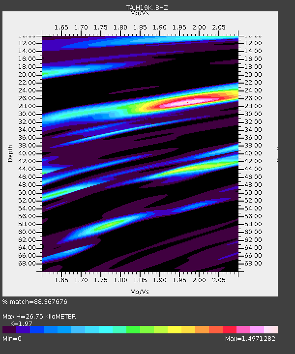
| Estimated Moho Depth: |
26.75 km |
| Estimated Crust Vp/Vs: |
1.97 |
| Assumed Crust Vp: |
6.182 km/s |
| Estimated Crust Vs: |
3.138 km/s |
| Estimated Crust Poisson's Ratio: |
0.33 |
|
| Radial Match: |
88.367676 % |
| Radial Bump: |
400 |
| Transverse Match: |
79.26758 % |
| Transverse Bump: |
400 |
| SOD ConfigId: |
20906531 |
| Insert Time: |
2020-04-08 12:31:58.871 +0000 |
| GWidth: |
2.5 |
| Max Bumps: |
400 |
| Tol: |
0.001 |
|

Signal To Noise
| Channel | StoN | STA | LTA |
| TA:H19K: :BHZ:20200318T13:15:54.475007Z | 9.222448 | 1.1172588E-6 | 1.2114558E-7 |
| TA:H19K: :BHN:20200318T13:15:54.475007Z | 2.58014 | 2.41987E-7 | 9.378832E-8 |
| TA:H19K: :BHE:20200318T13:15:54.475007Z | 5.5573344 | 6.289232E-7 | 1.1316994E-7 |
| Arrivals |
| Ps | 4.5 SECOND |
| PpPs | 12 SECOND |
| PsPs/PpSs | 17 SECOND |


