You are here: Home > Network List > DU - Seismological Association of Australia (SAA) Stations List
> Station TPSO The Peters Seismological Observatory > Earthquake Result Viewer
TPSO The Peters Seismological Observatory - Earthquake Result Viewer
| Earthquake location: |
South Of Bali, Indonesia |
| Earthquake latitude/longitude: |
-11.1/115.1 |
| Earthquake time(UTC): |
2020/03/18 (078) 17:45:39 GMT |
| Earthquake Depth: |
20 km |
| Earthquake Magnitude: |
6.2 mww |
| Earthquake Catalog/Contributor: |
NEIC PDE/us |
|
| Network: |
DU Seismological Association of Australia (SAA) |
| Station: |
TPSO The Peters Seismological Observatory |
| Lat/Lon: |
35.49 S/138.64 E |
| Elevation: |
77 m |
|
| Distance: |
32.3 deg |
| Az: |
142.549 deg |
| Baz: |
312.989 deg |
| Ray Param: |
0.078686684 |
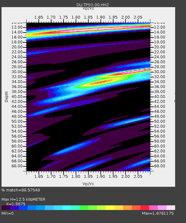
| Estimated Moho Depth: |
12.5 km |
| Estimated Crust Vp/Vs: |
1.89 |
| Assumed Crust Vp: |
6.576 km/s |
| Estimated Crust Vs: |
3.484 km/s |
| Estimated Crust Poisson's Ratio: |
0.30 |
|
| Radial Match: |
88.57548 % |
| Radial Bump: |
400 |
| Transverse Match: |
55.85174 % |
| Transverse Bump: |
400 |
| SOD ConfigId: |
20906531 |
| Insert Time: |
2020-04-08 12:35:34.630 +0000 |
| GWidth: |
2.5 |
| Max Bumps: |
400 |
| Tol: |
0.001 |
|

Signal To Noise
| Channel | StoN | STA | LTA |
| DU:TPSO:00:HHZ:20200318T17:51:36.460005Z | 7.9594917 | 0.52168196 | 0.065542124 |
| DU:TPSO:00:HHN:20200318T17:51:36.460005Z | 2.8208199 | 0.2109832 | 0.07479499 |
| DU:TPSO:00:HHE:20200318T17:51:36.460005Z | 3.0731676 | 0.2173367 | 0.07072075 |
| Arrivals |
| Ps | 1.8 SECOND |
| PpPs | 5.1 SECOND |
| PsPs/PpSs | 6.9 SECOND |


