You are here: Home > Network List > G - GEOSCOPE Stations List
> Station CRZF Port Alfred, Crozet, South Indian Ocean > Earthquake Result Viewer
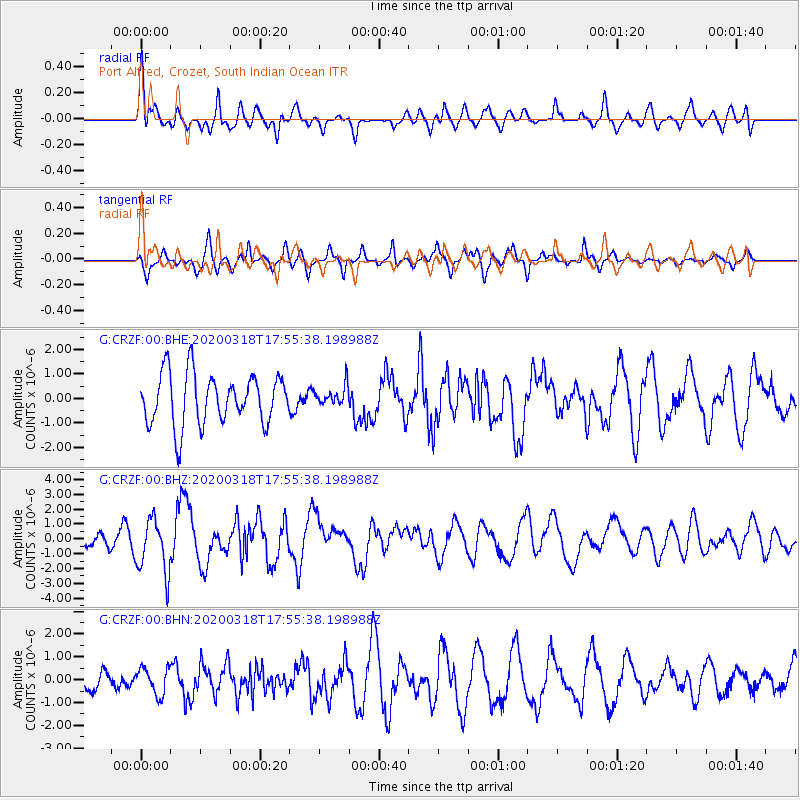
CRZF Port Alfred, Crozet, South Indian Ocean - Earthquake Result Viewer
*The percent match for this event was below the threshold and hence no stack was calculated.
| Earthquake location: |
South Of Bali, Indonesia |
| Earthquake latitude/longitude: |
-11.1/115.1 |
| Earthquake time(UTC): |
2020/03/18 (078) 17:45:39 GMT |
| Earthquake Depth: |
20 km |
| Earthquake Magnitude: |
6.2 mww |
| Earthquake Catalog/Contributor: |
NEIC PDE/us |
|
| Network: |
G GEOSCOPE |
| Station: |
CRZF Port Alfred, Crozet, South Indian Ocean |
| Lat/Lon: |
46.43 S/51.86 E |
| Elevation: |
140 m |
|
| Distance: |
63.7 deg |
| Az: |
223.56 deg |
| Baz: |
77.969 deg |
| Ray Param: |
$rayparam |
*The percent match for this event was below the threshold and hence was not used in the summary stack. |
|
| Radial Match: |
61.812183 % |
| Radial Bump: |
400 |
| Transverse Match: |
57.33932 % |
| Transverse Bump: |
400 |
| SOD ConfigId: |
20906531 |
| Insert Time: |
2020-04-08 12:35:40.716 +0000 |
| GWidth: |
2.5 |
| Max Bumps: |
400 |
| Tol: |
0.001 |
|
Signal To Noise
| Channel | StoN | STA | LTA |
| G:CRZF:00:BHZ:20200318T17:55:38.198988Z | 2.6917968 | 1.8375978E-6 | 6.826658E-7 |
| G:CRZF:00:BHN:20200318T17:55:38.198988Z | 0.9466193 | 5.798769E-7 | 6.125766E-7 |
| G:CRZF:00:BHE:20200318T17:55:38.198988Z | 0.39263922 | 4.0380502E-7 | 1.0284379E-6 |
| Arrivals |
| Ps | |
| PpPs | |
| PsPs/PpSs | |


