You are here: Home > Network List > TS - TERRAscope (Southern California Seismic Network) Stations List
> Station PFO Pinon Flat, California, USA > Earthquake Result Viewer
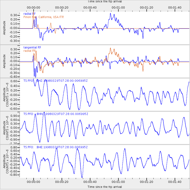
PFO Pinon Flat, California, USA - Earthquake Result Viewer
*The percent match for this event was below the threshold and hence no stack was calculated.
| Earthquake location: |
North Of Ascension Island |
| Earthquake latitude/longitude: |
-0.2/-17.9 |
| Earthquake time(UTC): |
1998/03/29 (088) 07:14:58 GMT |
| Earthquake Depth: |
10 km |
| Earthquake Magnitude: |
5.5 MB, 5.6 MS, 6.1 UNKNOWN, 6.1 MW |
| Earthquake Catalog/Contributor: |
WHDF/NEIC |
|
| Network: |
TS TERRAscope (Southern California Seismic Network) |
| Station: |
PFO Pinon Flat, California, USA |
| Lat/Lon: |
33.61 N/116.46 W |
| Elevation: |
1280 m |
|
| Distance: |
97.2 deg |
| Az: |
303.7 deg |
| Baz: |
85.479 deg |
| Ray Param: |
$rayparam |
*The percent match for this event was below the threshold and hence was not used in the summary stack. |
|
| Radial Match: |
63.675747 % |
| Radial Bump: |
400 |
| Transverse Match: |
66.118256 % |
| Transverse Bump: |
400 |
| SOD ConfigId: |
4480 |
| Insert Time: |
2010-02-26 14:44:32.749 +0000 |
| GWidth: |
2.5 |
| Max Bumps: |
400 |
| Tol: |
0.001 |
|
Signal To Noise
| Channel | StoN | STA | LTA |
| TS:PFO: :BHN:19980329T07:28:00.006995Z | 1.9690163 | 7.040031E-7 | 3.5754053E-7 |
| TS:PFO: :BHE:19980329T07:28:00.006995Z | 1.6375525 | 3.7112056E-7 | 2.2663126E-7 |
| TS:PFO: :BHZ:19980329T07:28:00.006995Z | 1.3593452 | 4.663481E-7 | 3.430682E-7 |
| Arrivals |
| Ps | |
| PpPs | |
| PsPs/PpSs | |


