You are here: Home > Network List > KR - Kyrgyz Digital Network Stations List
> Station KDJ Kadji-Say, Kyrgyzstan > Earthquake Result Viewer
KDJ Kadji-Say, Kyrgyzstan - Earthquake Result Viewer
| Earthquake location: |
South Of Bali, Indonesia |
| Earthquake latitude/longitude: |
-11.1/115.1 |
| Earthquake time(UTC): |
2020/03/18 (078) 17:45:39 GMT |
| Earthquake Depth: |
20 km |
| Earthquake Magnitude: |
6.2 mww |
| Earthquake Catalog/Contributor: |
NEIC PDE/us |
|
| Network: |
KR Kyrgyz Digital Network |
| Station: |
KDJ Kadji-Say, Kyrgyzstan |
| Lat/Lon: |
42.12 N/77.18 E |
| Elevation: |
1830 m |
|
| Distance: |
63.4 deg |
| Az: |
329.2 deg |
| Baz: |
137.497 deg |
| Ray Param: |
0.059611388 |
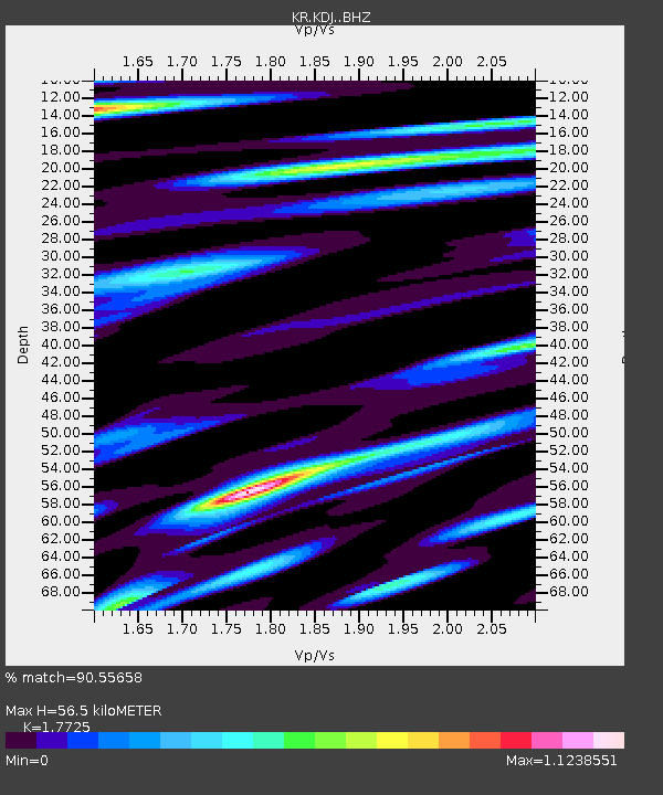
| Estimated Moho Depth: |
56.5 km |
| Estimated Crust Vp/Vs: |
1.77 |
| Assumed Crust Vp: |
6.306 km/s |
| Estimated Crust Vs: |
3.558 km/s |
| Estimated Crust Poisson's Ratio: |
0.27 |
|
| Radial Match: |
90.55658 % |
| Radial Bump: |
400 |
| Transverse Match: |
90.87638 % |
| Transverse Bump: |
400 |
| SOD ConfigId: |
20906531 |
| Insert Time: |
2020-04-08 12:37:49.500 +0000 |
| GWidth: |
2.5 |
| Max Bumps: |
400 |
| Tol: |
0.001 |
|

Signal To Noise
| Channel | StoN | STA | LTA |
| KR:KDJ: :BHZ:20200318T17:55:35.880018Z | 11.912873 | 3.38752E-6 | 2.8435792E-7 |
| KR:KDJ: :BHN:20200318T17:55:35.880018Z | 2.629156 | 4.8621007E-7 | 1.849301E-7 |
| KR:KDJ: :BHE:20200318T17:55:35.880018Z | 3.8831434 | 5.8684776E-7 | 1.51127E-7 |
| Arrivals |
| Ps | 7.2 SECOND |
| PpPs | 24 SECOND |
| PsPs/PpSs | 31 SECOND |


