You are here: Home > Network List > S1 - Australian Seismometers in Schools Stations List
> Station AUMTS Mt Stromlo > Earthquake Result Viewer
AUMTS Mt Stromlo - Earthquake Result Viewer
| Earthquake location: |
South Of Bali, Indonesia |
| Earthquake latitude/longitude: |
-11.1/115.1 |
| Earthquake time(UTC): |
2020/03/18 (078) 17:45:39 GMT |
| Earthquake Depth: |
20 km |
| Earthquake Magnitude: |
6.2 mww |
| Earthquake Catalog/Contributor: |
NEIC PDE/us |
|
| Network: |
S1 Australian Seismometers in Schools |
| Station: |
AUMTS Mt Stromlo |
| Lat/Lon: |
35.32 S/149.00 E |
| Elevation: |
667 m |
|
| Distance: |
39.1 deg |
| Az: |
133.713 deg |
| Baz: |
299.811 deg |
| Ray Param: |
0.075194 |
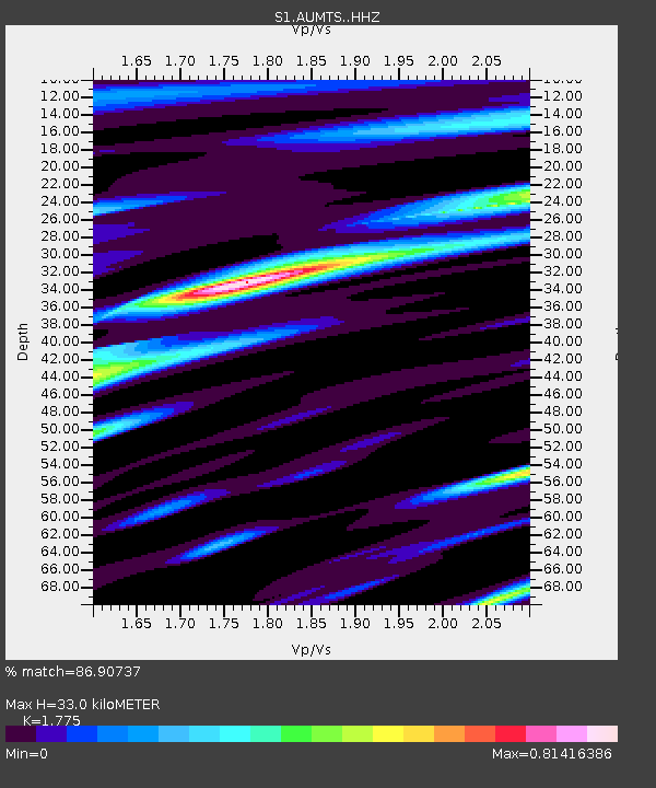
| Estimated Moho Depth: |
33.0 km |
| Estimated Crust Vp/Vs: |
1.77 |
| Assumed Crust Vp: |
6.633 km/s |
| Estimated Crust Vs: |
3.737 km/s |
| Estimated Crust Poisson's Ratio: |
0.27 |
|
| Radial Match: |
86.90737 % |
| Radial Bump: |
330 |
| Transverse Match: |
70.00346 % |
| Transverse Bump: |
400 |
| SOD ConfigId: |
20906531 |
| Insert Time: |
2020-04-08 12:38:56.411 +0000 |
| GWidth: |
2.5 |
| Max Bumps: |
400 |
| Tol: |
0.001 |
|

Signal To Noise
| Channel | StoN | STA | LTA |
| S1:AUMTS: :HHZ:20200318T17:52:34.009992Z | 3.9809718 | 7.209462E-7 | 1.8109805E-7 |
| S1:AUMTS: :HHN:20200318T17:52:34.009992Z | 0.54317725 | 1.5360456E-7 | 2.8278902E-7 |
| S1:AUMTS: :HHE:20200318T17:52:34.009992Z | 1.4337254 | 3.3850642E-7 | 2.3610268E-7 |
| Arrivals |
| Ps | 4.2 SECOND |
| PpPs | 13 SECOND |
| PsPs/PpSs | 17 SECOND |


