You are here: Home > Network List > TA - USArray Transportable Network (new EarthScope stations) Stations List
> Station D17K Noatak River, AK, USA > Earthquake Result Viewer
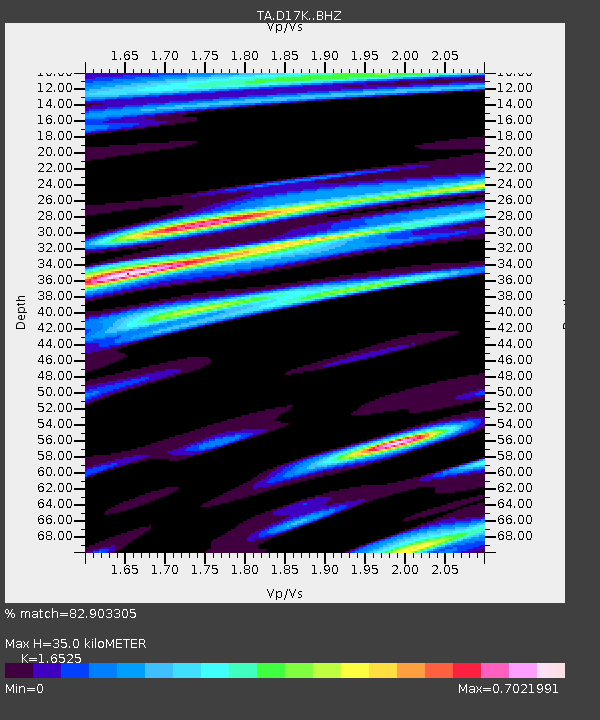
D17K Noatak River, AK, USA - Earthquake Result Viewer
| Earthquake location: |
South Of Bali, Indonesia |
| Earthquake latitude/longitude: |
-11.1/115.1 |
| Earthquake time(UTC): |
2020/03/18 (078) 17:45:39 GMT |
| Earthquake Depth: |
20 km |
| Earthquake Magnitude: |
6.2 mww |
| Earthquake Catalog/Contributor: |
NEIC PDE/us |
|
| Network: |
TA USArray Transportable Network (new EarthScope stations) |
| Station: |
D17K Noatak River, AK, USA |
| Lat/Lon: |
67.70 N/163.08 W |
| Elevation: |
172 m |
|
| Distance: |
97.0 deg |
| Az: |
22.371 deg |
| Baz: |
258.22 deg |
| Ray Param: |
0.04033171 |
| Estimated Moho Depth: |
35.0 km |
| Estimated Crust Vp/Vs: |
1.65 |
| Assumed Crust Vp: |
6.276 km/s |
| Estimated Crust Vs: |
3.798 km/s |
| Estimated Crust Poisson's Ratio: |
0.21 |
|
| Radial Match: |
82.903305 % |
| Radial Bump: |
400 |
| Transverse Match: |
78.26961 % |
| Transverse Bump: |
400 |
| SOD ConfigId: |
20906531 |
| Insert Time: |
2020-04-08 12:39:07.710 +0000 |
| GWidth: |
2.5 |
| Max Bumps: |
400 |
| Tol: |
0.001 |
|

Signal To Noise
| Channel | StoN | STA | LTA |
| TA:D17K: :BHZ:20200318T17:58:37.875013Z | 3.9993708 | 2.9677028E-7 | 7.420424E-8 |
| TA:D17K: :BHN:20200318T17:58:37.875013Z | 1.1326494 | 1.0547424E-7 | 9.31217E-8 |
| TA:D17K: :BHE:20200318T17:58:37.875013Z | 2.4197977 | 1.5139976E-7 | 6.256712E-8 |
| Arrivals |
| Ps | 3.7 SECOND |
| PpPs | 15 SECOND |
| PsPs/PpSs | 18 SECOND |


