You are here: Home > Network List > TJ - Tajikistan National Seismic Network Stations List
> Station GARM Garm, Tajikistan > Earthquake Result Viewer
GARM Garm, Tajikistan - Earthquake Result Viewer
| Earthquake location: |
South Of Bali, Indonesia |
| Earthquake latitude/longitude: |
-11.1/115.1 |
| Earthquake time(UTC): |
2020/03/18 (078) 17:45:39 GMT |
| Earthquake Depth: |
20 km |
| Earthquake Magnitude: |
6.2 mww |
| Earthquake Catalog/Contributor: |
NEIC PDE/us |
|
| Network: |
TJ Tajikistan National Seismic Network |
| Station: |
GARM Garm, Tajikistan |
| Lat/Lon: |
39.00 N/70.32 E |
| Elevation: |
1305 m |
|
| Distance: |
65.0 deg |
| Az: |
322.682 deg |
| Baz: |
130.203 deg |
| Ray Param: |
0.058558445 |
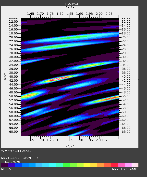
| Estimated Moho Depth: |
40.75 km |
| Estimated Crust Vp/Vs: |
1.80 |
| Assumed Crust Vp: |
6.306 km/s |
| Estimated Crust Vs: |
3.508 km/s |
| Estimated Crust Poisson's Ratio: |
0.28 |
|
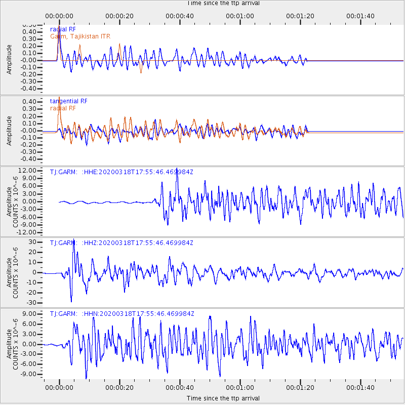
| Radial Match: |
88.04542 % |
| Radial Bump: |
400 |
| Transverse Match: |
84.43626 % |
| Transverse Bump: |
400 |
| SOD ConfigId: |
20906531 |
| Insert Time: |
2020-04-08 12:39:39.630 +0000 |
| GWidth: |
2.5 |
| Max Bumps: |
400 |
| Tol: |
0.001 |
|
Signal To Noise
| Channel | StoN | STA | LTA |
| TJ:GARM: :HHZ:20200318T17:55:46.469984Z | 42.55042 | 1.0538901E-5 | 2.476803E-7 |
| TJ:GARM: :HHN:20200318T17:55:46.469984Z | 9.084352 | 2.1825283E-6 | 2.402514E-7 |
| TJ:GARM: :HHE:20200318T17:55:46.469984Z | 8.540544 | 2.3280222E-6 | 2.7258477E-7 |
| Arrivals |
| Ps | 5.4 SECOND |
| PpPs | 17 SECOND |
| PsPs/PpSs | 23 SECOND |


