You are here: Home > Network List > TS - TERRAscope (Southern California Seismic Network) Stations List
> Station PFO Pinon Flat, California, USA > Earthquake Result Viewer
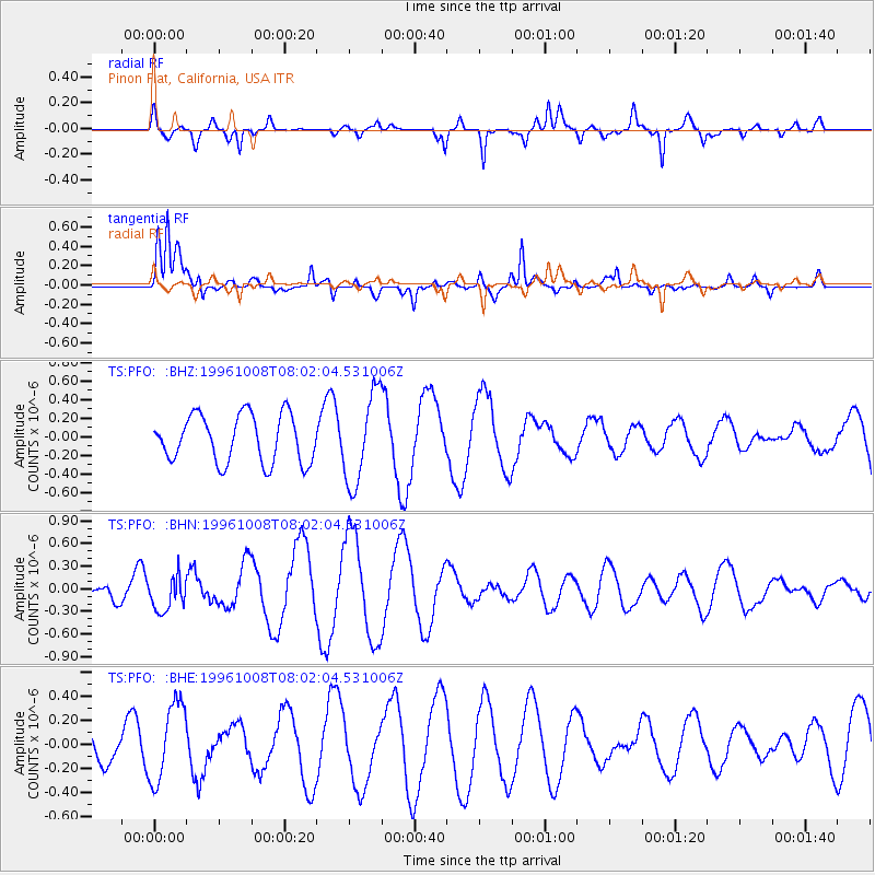
PFO Pinon Flat, California, USA - Earthquake Result Viewer
*The percent match for this event was below the threshold and hence no stack was calculated.
| Earthquake location: |
Northwest Of Kuril Islands |
| Earthquake latitude/longitude: |
52.9/152.5 |
| Earthquake time(UTC): |
1996/10/08 (282) 07:52:58 GMT |
| Earthquake Depth: |
627 km |
| Earthquake Magnitude: |
5.6 UNKNOWN, 5.2 MB |
| Earthquake Catalog/Contributor: |
WHDF/NEIC |
|
| Network: |
TS TERRAscope (Southern California Seismic Network) |
| Station: |
PFO Pinon Flat, California, USA |
| Lat/Lon: |
33.61 N/116.46 W |
| Elevation: |
1280 m |
|
| Distance: |
64.6 deg |
| Az: |
67.497 deg |
| Baz: |
317.853 deg |
| Ray Param: |
$rayparam |
*The percent match for this event was below the threshold and hence was not used in the summary stack. |
|
| Radial Match: |
70.1717 % |
| Radial Bump: |
332 |
| Transverse Match: |
65.35385 % |
| Transverse Bump: |
400 |
| SOD ConfigId: |
4480 |
| Insert Time: |
2010-02-26 14:44:35.331 +0000 |
| GWidth: |
2.5 |
| Max Bumps: |
400 |
| Tol: |
0.001 |
|
Signal To Noise
| Channel | StoN | STA | LTA |
| TS:PFO: :BHN:19961008T08:02:04.531006Z | 1.2408206 | 2.2520288E-7 | 1.8149511E-7 |
| TS:PFO: :BHE:19961008T08:02:04.531006Z | 1.6351098 | 3.2621557E-7 | 1.9950683E-7 |
| TS:PFO: :BHZ:19961008T08:02:04.531006Z | 1.9014571 | 4.856623E-7 | 2.5541587E-7 |
| Arrivals |
| Ps | |
| PpPs | |
| PsPs/PpSs | |


