You are here: Home > Network List > US - United States National Seismic Network Stations List
> Station AGMN Agassiz National Wildlife Refuge, Minnesota, USA > Earthquake Result Viewer
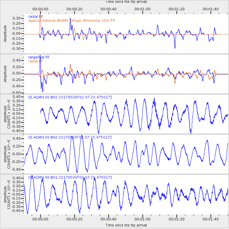
AGMN Agassiz National Wildlife Refuge, Minnesota, USA - Earthquake Result Viewer
*The percent match for this event was below the threshold and hence no stack was calculated.
| Earthquake location: |
Ryukyu Islands, Japan |
| Earthquake latitude/longitude: |
24.4/126.3 |
| Earthquake time(UTC): |
2017/05/09 (129) 01:54:14 GMT |
| Earthquake Depth: |
10 km |
| Earthquake Magnitude: |
6.0 Mww |
| Earthquake Catalog/Contributor: |
NEIC PDE/us |
|
| Network: |
US United States National Seismic Network |
| Station: |
AGMN Agassiz National Wildlife Refuge, Minnesota, USA |
| Lat/Lon: |
48.30 N/95.86 W |
| Elevation: |
351 m |
|
| Distance: |
98.3 deg |
| Az: |
26.929 deg |
| Baz: |
321.819 deg |
| Ray Param: |
$rayparam |
*The percent match for this event was below the threshold and hence was not used in the summary stack. |
|
| Radial Match: |
52.849846 % |
| Radial Bump: |
400 |
| Transverse Match: |
70.88747 % |
| Transverse Bump: |
400 |
| SOD ConfigId: |
2028011 |
| Insert Time: |
2017-05-23 01:56:31.388 +0000 |
| GWidth: |
2.5 |
| Max Bumps: |
400 |
| Tol: |
0.001 |
|
Signal To Noise
| Channel | StoN | STA | LTA |
| US:AGMN:00:BHZ:20170509T02:07:20.475017Z | 0.6804859 | 1.4519208E-7 | 2.1336528E-7 |
| US:AGMN:00:BH1:20170509T02:07:20.475017Z | 0.8960576 | 2.3898406E-7 | 2.6670614E-7 |
| US:AGMN:00:BH2:20170509T02:07:20.475017Z | 2.0782516 | 2.446081E-7 | 1.17698974E-7 |
| Arrivals |
| Ps | |
| PpPs | |
| PsPs/PpSs | |


