You are here: Home > Network List > TS - TERRAscope (Southern California Seismic Network) Stations List
> Station PFO Pinon Flat, California, USA > Earthquake Result Viewer
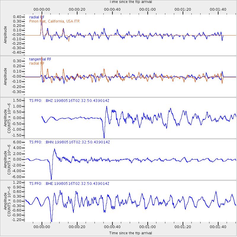
PFO Pinon Flat, California, USA - Earthquake Result Viewer
*The percent match for this event was below the threshold and hence no stack was calculated.
| Earthquake location: |
South Of Fiji Islands |
| Earthquake latitude/longitude: |
-22.2/-179.5 |
| Earthquake time(UTC): |
1998/05/16 (136) 02:22:03 GMT |
| Earthquake Depth: |
586 km |
| Earthquake Magnitude: |
6.1 MB, 6.8 UNKNOWN |
| Earthquake Catalog/Contributor: |
WHDF/NEIC |
|
| Network: |
TS TERRAscope (Southern California Seismic Network) |
| Station: |
PFO Pinon Flat, California, USA |
| Lat/Lon: |
33.61 N/116.46 W |
| Elevation: |
1280 m |
|
| Distance: |
81.8 deg |
| Az: |
48.741 deg |
| Baz: |
236.578 deg |
| Ray Param: |
$rayparam |
*The percent match for this event was below the threshold and hence was not used in the summary stack. |
|
| Radial Match: |
67.63393 % |
| Radial Bump: |
317 |
| Transverse Match: |
69.55735 % |
| Transverse Bump: |
400 |
| SOD ConfigId: |
4480 |
| Insert Time: |
2010-02-26 14:44:37.867 +0000 |
| GWidth: |
2.5 |
| Max Bumps: |
400 |
| Tol: |
0.001 |
|
Signal To Noise
| Channel | StoN | STA | LTA |
| TS:PFO: :BHN:19980516T02:32:50.439014Z | 5.8716755 | 1.0029935E-6 | 1.7081895E-7 |
| TS:PFO: :BHE:19980516T02:32:50.439014Z | 1.5410515 | 2.3820684E-7 | 1.5457422E-7 |
| TS:PFO: :BHZ:19980516T02:32:50.439014Z | 2.060835 | 2.312747E-7 | 1.1222379E-7 |
| Arrivals |
| Ps | |
| PpPs | |
| PsPs/PpSs | |


