You are here: Home > Network List > KN - Kyrgyz Seismic Telemetry Network Stations List
> Station AAK KN.AAK > Earthquake Result Viewer
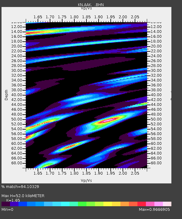
AAK KN.AAK - Earthquake Result Viewer
| Earthquake location: |
Northwest Of Kuril Islands |
| Earthquake latitude/longitude: |
47.8/146.2 |
| Earthquake time(UTC): |
2002/11/17 (321) 04:53:53 GMT |
| Earthquake Depth: |
459 km |
| Earthquake Magnitude: |
7.3 MW, 7.3 MW |
| Earthquake Catalog/Contributor: |
WHDF/NEIC |
|
| Network: |
KN Kyrgyz Seismic Telemetry Network |
| Station: |
AAK KN.AAK |
| Lat/Lon: |
42.63 N/74.49 E |
| Elevation: |
1680 m |
|
| Distance: |
49.1 deg |
| Az: |
292.042 deg |
| Baz: |
57.825 deg |
| Ray Param: |
0.06692744 |
| Estimated Moho Depth: |
52.0 km |
| Estimated Crust Vp/Vs: |
1.65 |
| Assumed Crust Vp: |
6.306 km/s |
| Estimated Crust Vs: |
3.822 km/s |
| Estimated Crust Poisson's Ratio: |
0.21 |
|
| Radial Match: |
94.10329 % |
| Radial Bump: |
400 |
| Transverse Match: |
89.26887 % |
| Transverse Bump: |
400 |
| SOD ConfigId: |
4714 |
| Insert Time: |
2010-03-08 18:29:10.268 +0000 |
| GWidth: |
2.5 |
| Max Bumps: |
400 |
| Tol: |
0.001 |
|

Signal To Noise
| Channel | StoN | STA | LTA |
| KN:AAK: :BHN:20021117T05:01:27.075004Z | 27.8254 | 3.822155E-6 | 1.3736208E-7 |
| KN:AAK: :BHE:20021117T05:01:27.075004Z | 48.99731 | 7.2635844E-6 | 1.4824455E-7 |
| KN:AAK: :BHZ:20021117T05:01:27.075004Z | 69.30083 | 1.6850541E-5 | 2.4315065E-7 |
| Arrivals |
| Ps | 5.7 SECOND |
| PpPs | 21 SECOND |
| PsPs/PpSs | 26 SECOND |


