You are here: Home > Network List > TA - USArray Transportable Network (new EarthScope stations) Stations List
> Station R33M Jennings River, BC, CAN > Earthquake Result Viewer
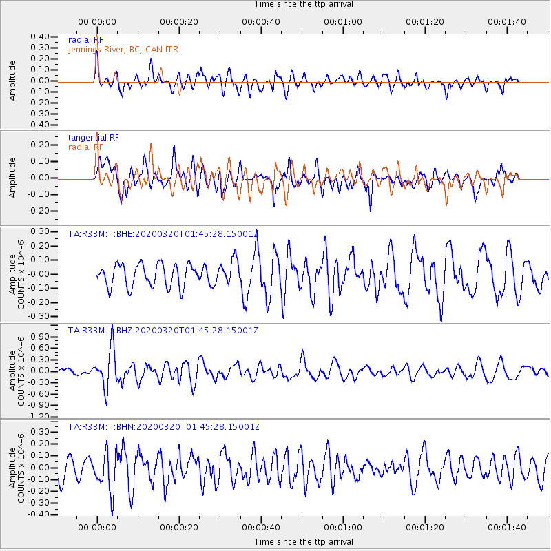
R33M Jennings River, BC, CAN - Earthquake Result Viewer
*The percent match for this event was below the threshold and hence no stack was calculated.
| Earthquake location: |
Xizang |
| Earthquake latitude/longitude: |
28.6/87.3 |
| Earthquake time(UTC): |
2020/03/20 (080) 01:33:15 GMT |
| Earthquake Depth: |
10 km |
| Earthquake Magnitude: |
5.7 mww |
| Earthquake Catalog/Contributor: |
NEIC PDE/us |
|
| Network: |
TA USArray Transportable Network (new EarthScope stations) |
| Station: |
R33M Jennings River, BC, CAN |
| Lat/Lon: |
59.39 N/130.97 W |
| Elevation: |
1437 m |
|
| Distance: |
86.8 deg |
| Az: |
18.518 deg |
| Baz: |
326.922 deg |
| Ray Param: |
$rayparam |
*The percent match for this event was below the threshold and hence was not used in the summary stack. |
|
| Radial Match: |
63.89507 % |
| Radial Bump: |
400 |
| Transverse Match: |
55.677326 % |
| Transverse Bump: |
400 |
| SOD ConfigId: |
20906531 |
| Insert Time: |
2020-04-08 12:55:04.891 +0000 |
| GWidth: |
2.5 |
| Max Bumps: |
400 |
| Tol: |
0.001 |
|
Signal To Noise
| Channel | StoN | STA | LTA |
| TA:R33M: :BHZ:20200320T01:45:28.15001Z | 4.7951436 | 5.276691E-7 | 1.1004239E-7 |
| TA:R33M: :BHN:20200320T01:45:28.15001Z | 1.8985453 | 1.6795624E-7 | 8.8465754E-8 |
| TA:R33M: :BHE:20200320T01:45:28.15001Z | 1.0533049 | 8.386896E-8 | 7.962458E-8 |
| Arrivals |
| Ps | |
| PpPs | |
| PsPs/PpSs | |


