You are here: Home > Network List > TS - TERRAscope (Southern California Seismic Network) Stations List
> Station PFO Pinon Flat, California, USA > Earthquake Result Viewer
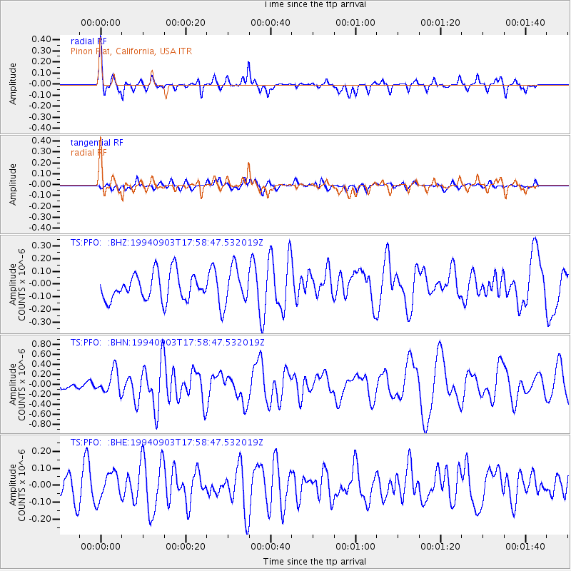
PFO Pinon Flat, California, USA - Earthquake Result Viewer
*The percent match for this event was below the threshold and hence no stack was calculated.
| Earthquake location: |
Vanuatu Islands Region |
| Earthquake latitude/longitude: |
-21.3/173.6 |
| Earthquake time(UTC): |
1994/09/03 (246) 17:46:41 GMT |
| Earthquake Depth: |
33 km |
| Earthquake Magnitude: |
5.7 MB, 6.2 MS, 6.3 UNKNOWN, 6.2 MW |
| Earthquake Catalog/Contributor: |
WHDF/NEIC |
|
| Network: |
TS TERRAscope (Southern California Seismic Network) |
| Station: |
PFO Pinon Flat, California, USA |
| Lat/Lon: |
33.61 N/116.46 W |
| Elevation: |
1280 m |
|
| Distance: |
86.1 deg |
| Az: |
51.774 deg |
| Baz: |
241.398 deg |
| Ray Param: |
$rayparam |
*The percent match for this event was below the threshold and hence was not used in the summary stack. |
|
| Radial Match: |
77.08393 % |
| Radial Bump: |
323 |
| Transverse Match: |
58.051495 % |
| Transverse Bump: |
400 |
| SOD ConfigId: |
4480 |
| Insert Time: |
2010-02-26 14:44:38.776 +0000 |
| GWidth: |
2.5 |
| Max Bumps: |
400 |
| Tol: |
0.001 |
|
Signal To Noise
| Channel | StoN | STA | LTA |
| TS:PFO: :BHN:19940903T17:58:47.532019Z | 2.0789268 | 2.3193998E-7 | 1.11567175E-7 |
| TS:PFO: :BHE:19940903T17:58:47.532019Z | 0.98357546 | 8.0341685E-8 | 8.168329E-8 |
| TS:PFO: :BHZ:19940903T17:58:47.532019Z | 1.320625 | 1.367532E-7 | 1.03551876E-7 |
| Arrivals |
| Ps | |
| PpPs | |
| PsPs/PpSs | |


