You are here: Home > Network List > IU - Global Seismograph Network (GSN - IRIS/USGS) Stations List
> Station RSSD Black Hills, South Dakota, USA > Earthquake Result Viewer
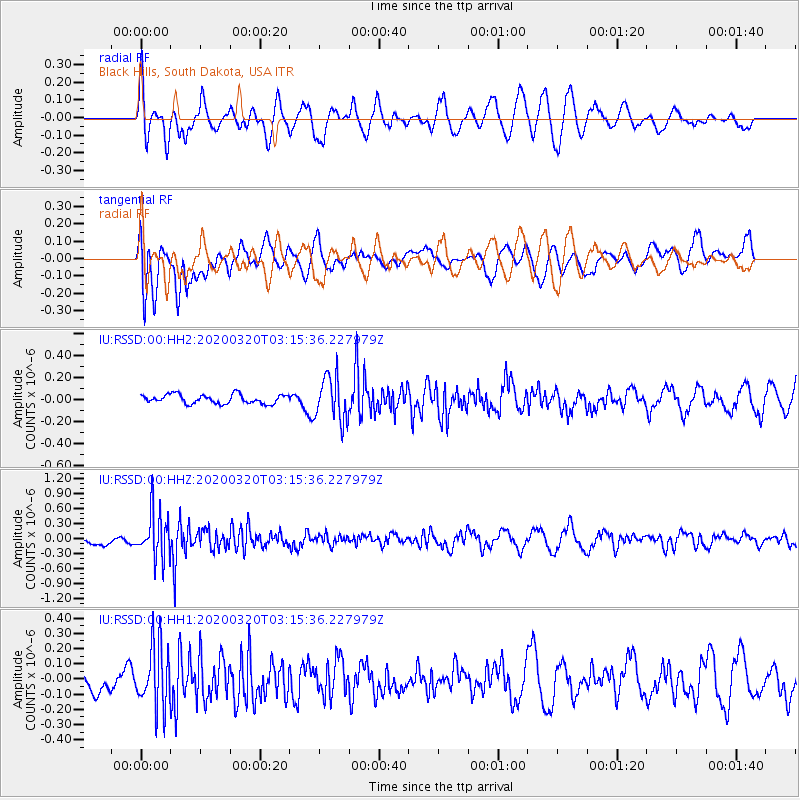
RSSD Black Hills, South Dakota, USA - Earthquake Result Viewer
*The percent match for this event was below the threshold and hence no stack was calculated.
| Earthquake location: |
Mongolia |
| Earthquake latitude/longitude: |
46.1/94.0 |
| Earthquake time(UTC): |
2020/03/20 (080) 03:03:13 GMT |
| Earthquake Depth: |
10 km |
| Earthquake Magnitude: |
5.5 Mww |
| Earthquake Catalog/Contributor: |
NEIC PDE/us |
|
| Network: |
IU Global Seismograph Network (GSN - IRIS/USGS) |
| Station: |
RSSD Black Hills, South Dakota, USA |
| Lat/Lon: |
44.12 N/104.04 W |
| Elevation: |
2090 m |
|
| Distance: |
88.8 deg |
| Az: |
12.858 deg |
| Baz: |
347.574 deg |
| Ray Param: |
$rayparam |
*The percent match for this event was below the threshold and hence was not used in the summary stack. |
|
| Radial Match: |
63.462093 % |
| Radial Bump: |
363 |
| Transverse Match: |
69.04564 % |
| Transverse Bump: |
400 |
| SOD ConfigId: |
20906531 |
| Insert Time: |
2020-04-08 13:07:10.888 +0000 |
| GWidth: |
2.5 |
| Max Bumps: |
400 |
| Tol: |
0.001 |
|
Signal To Noise
| Channel | StoN | STA | LTA |
| IU:RSSD:00:HHZ:20200320T03:15:36.227979Z | 5.8025737 | 4.5147073E-7 | 7.7805254E-8 |
| IU:RSSD:00:HH1:20200320T03:15:36.227979Z | 2.8761973 | 2.0674644E-7 | 7.1881864E-8 |
| IU:RSSD:00:HH2:20200320T03:15:36.227979Z | 4.8961573 | 2.0285772E-7 | 4.1432028E-8 |
| Arrivals |
| Ps | |
| PpPs | |
| PsPs/PpSs | |


