You are here: Home > Network List > TS - TERRAscope (Southern California Seismic Network) Stations List
> Station RPV Rancho Palos Verde California, USA > Earthquake Result Viewer
RPV Rancho Palos Verde California, USA - Earthquake Result Viewer
| Earthquake location: |
Hokkaido, Japan Region |
| Earthquake latitude/longitude: |
42.8/139.2 |
| Earthquake time(UTC): |
1993/07/12 (193) 13:17:11 GMT |
| Earthquake Depth: |
17 km |
| Earthquake Magnitude: |
6.7 MB, 7.6 MS, 7.3 UNKNOWN, 7.8 MW |
| Earthquake Catalog/Contributor: |
WHDF/NEIC |
|
| Network: |
TS TERRAscope (Southern California Seismic Network) |
| Station: |
RPV Rancho Palos Verde California, USA |
| Lat/Lon: |
33.74 N/118.40 W |
| Elevation: |
115 m |
|
| Distance: |
75.9 deg |
| Az: |
57.06 deg |
| Baz: |
312.2 deg |
| Ray Param: |
0.0513401 |
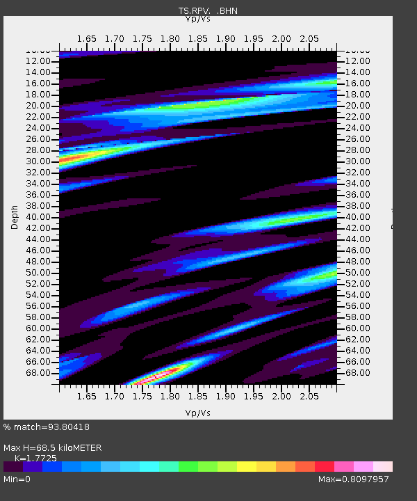
| Estimated Moho Depth: |
68.5 km |
| Estimated Crust Vp/Vs: |
1.77 |
| Assumed Crust Vp: |
6.048 km/s |
| Estimated Crust Vs: |
3.412 km/s |
| Estimated Crust Poisson's Ratio: |
0.27 |
|
| Radial Match: |
93.80418 % |
| Radial Bump: |
400 |
| Transverse Match: |
92.77844 % |
| Transverse Bump: |
400 |
| SOD ConfigId: |
16938 |
| Insert Time: |
2010-02-26 14:44:46.772 +0000 |
| GWidth: |
2.5 |
| Max Bumps: |
400 |
| Tol: |
0.001 |
|
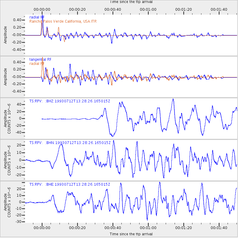
Signal To Noise
| Channel | StoN | STA | LTA |
| TS:RPV: :BHN:19930712T13:28:26.165015Z | 1.6600254 | 1.2798572E-6 | 7.709865E-7 |
| TS:RPV: :BHE:19930712T13:28:26.165015Z | 3.8778424 | 1.5557436E-6 | 4.0118792E-7 |
| TS:RPV: :BHZ:19930712T13:28:26.165015Z | 10.604472 | 6.2184367E-6 | 5.863976E-7 |
| Arrivals |
| Ps | 9.0 SECOND |
| PpPs | 31 SECOND |
| PsPs/PpSs | 40 SECOND |


