You are here: Home > Network List > KR - Kyrgyz Digital Network Stations List
> Station TRKS Terek-Say, Kyrgyzstan > Earthquake Result Viewer
TRKS Terek-Say, Kyrgyzstan - Earthquake Result Viewer
| Earthquake location: |
Greece-Albania Border Region |
| Earthquake latitude/longitude: |
39.4/20.6 |
| Earthquake time(UTC): |
2020/03/21 (081) 00:49:51 GMT |
| Earthquake Depth: |
10 km |
| Earthquake Magnitude: |
5.7 Mww |
| Earthquake Catalog/Contributor: |
NEIC PDE/us |
|
| Network: |
KR Kyrgyz Digital Network |
| Station: |
TRKS Terek-Say, Kyrgyzstan |
| Lat/Lon: |
41.46 N/71.17 E |
| Elevation: |
1518 m |
|
| Distance: |
38.1 deg |
| Az: |
70.151 deg |
| Baz: |
284.066 deg |
| Ray Param: |
0.07576992 |
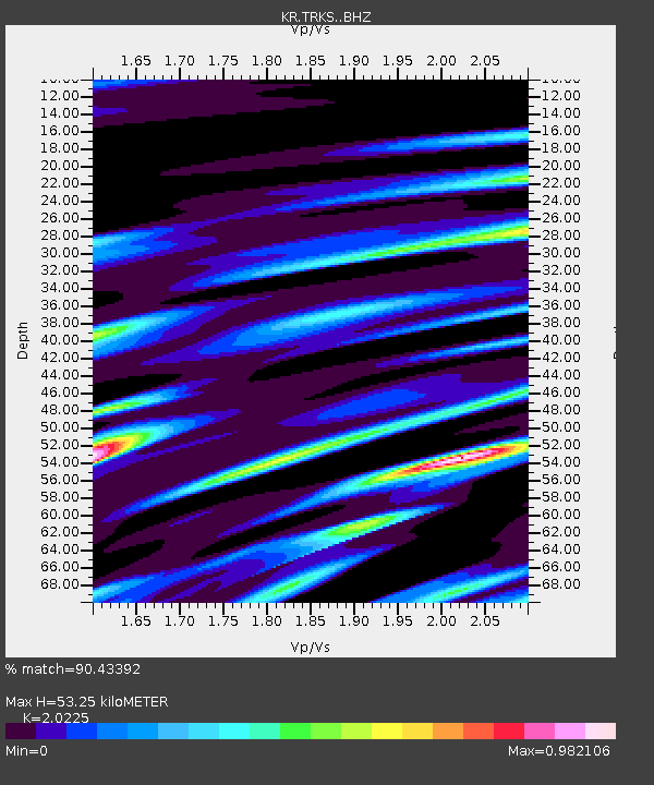
| Estimated Moho Depth: |
53.25 km |
| Estimated Crust Vp/Vs: |
2.02 |
| Assumed Crust Vp: |
6.236 km/s |
| Estimated Crust Vs: |
3.083 km/s |
| Estimated Crust Poisson's Ratio: |
0.34 |
|
| Radial Match: |
90.43392 % |
| Radial Bump: |
400 |
| Transverse Match: |
71.71055 % |
| Transverse Bump: |
400 |
| SOD ConfigId: |
20906531 |
| Insert Time: |
2020-04-08 13:31:20.176 +0000 |
| GWidth: |
2.5 |
| Max Bumps: |
400 |
| Tol: |
0.001 |
|

Signal To Noise
| Channel | StoN | STA | LTA |
| KR:TRKS: :BHZ:20200321T00:56:39.479992Z | 16.518074 | 7.909744E-7 | 4.7885386E-8 |
| KR:TRKS: :BHN:20200321T00:56:39.479992Z | 2.946217 | 2.2048243E-7 | 7.4835775E-8 |
| KR:TRKS: :BHE:20200321T00:56:39.479992Z | 5.576661 | 5.2778813E-7 | 9.4642324E-8 |
| Arrivals |
| Ps | 9.3 SECOND |
| PpPs | 24 SECOND |
| PsPs/PpSs | 34 SECOND |


