You are here: Home > Network List > TS - TERRAscope (Southern California Seismic Network) Stations List
> Station RPV Rancho Palos Verde California, USA > Earthquake Result Viewer
RPV Rancho Palos Verde California, USA - Earthquake Result Viewer
| Earthquake location: |
South Of Fiji Islands |
| Earthquake latitude/longitude: |
-23.9/179.8 |
| Earthquake time(UTC): |
1993/08/07 (219) 17:53:27 GMT |
| Earthquake Depth: |
555 km |
| Earthquake Magnitude: |
6.0 MB, 5.9 UNKNOWN, 6.9 MW |
| Earthquake Catalog/Contributor: |
WHDF/NEIC |
|
| Network: |
TS TERRAscope (Southern California Seismic Network) |
| Station: |
RPV Rancho Palos Verde California, USA |
| Lat/Lon: |
33.74 N/118.40 W |
| Elevation: |
115 m |
|
| Distance: |
82.1 deg |
| Az: |
47.844 deg |
| Baz: |
234.533 deg |
| Ray Param: |
0.0455136 |
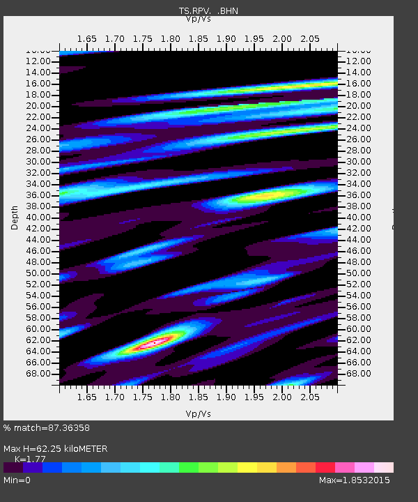
| Estimated Moho Depth: |
62.25 km |
| Estimated Crust Vp/Vs: |
1.77 |
| Assumed Crust Vp: |
6.048 km/s |
| Estimated Crust Vs: |
3.417 km/s |
| Estimated Crust Poisson's Ratio: |
0.27 |
|
| Radial Match: |
87.36358 % |
| Radial Bump: |
400 |
| Transverse Match: |
77.978615 % |
| Transverse Bump: |
400 |
| SOD ConfigId: |
16938 |
| Insert Time: |
2010-02-26 14:44:48.360 +0000 |
| GWidth: |
2.5 |
| Max Bumps: |
400 |
| Tol: |
0.001 |
|
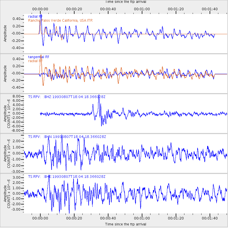
Signal To Noise
| Channel | StoN | STA | LTA |
| TS:RPV: :BHN:19930807T18:04:18.366028Z | 2.5547311 | 9.932357E-7 | 3.8878287E-7 |
| TS:RPV: :BHE:19930807T18:04:18.366028Z | 2.3142126 | 9.0823244E-7 | 3.9245853E-7 |
| TS:RPV: :BHZ:19930807T18:04:18.366028Z | 10.896611 | 2.952199E-6 | 2.7092818E-7 |
| Arrivals |
| Ps | 8.1 SECOND |
| PpPs | 28 SECOND |
| PsPs/PpSs | 36 SECOND |


