You are here: Home > Network List > TS - TERRAscope (Southern California Seismic Network) Stations List
> Station RPV Rancho Palos Verde California, USA > Earthquake Result Viewer
RPV Rancho Palos Verde California, USA - Earthquake Result Viewer
| Earthquake location: |
Hokkaido, Japan Region |
| Earthquake latitude/longitude: |
42.0/139.9 |
| Earthquake time(UTC): |
1993/08/07 (219) 19:42:43 GMT |
| Earthquake Depth: |
26 km |
| Earthquake Magnitude: |
6.2 MB, 6.0 MS, 5.6 UNKNOWN, 6.3 MW |
| Earthquake Catalog/Contributor: |
WHDF/NEIC |
|
| Network: |
TS TERRAscope (Southern California Seismic Network) |
| Station: |
RPV Rancho Palos Verde California, USA |
| Lat/Lon: |
33.74 N/118.40 W |
| Elevation: |
115 m |
|
| Distance: |
76.0 deg |
| Az: |
57.224 deg |
| Baz: |
311.182 deg |
| Ray Param: |
0.05125561 |
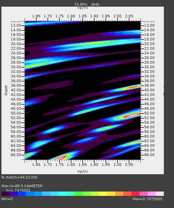
| Estimated Moho Depth: |
69.5 km |
| Estimated Crust Vp/Vs: |
1.75 |
| Assumed Crust Vp: |
6.048 km/s |
| Estimated Crust Vs: |
3.461 km/s |
| Estimated Crust Poisson's Ratio: |
0.26 |
|
| Radial Match: |
84.02355 % |
| Radial Bump: |
400 |
| Transverse Match: |
83.30392 % |
| Transverse Bump: |
400 |
| SOD ConfigId: |
16938 |
| Insert Time: |
2010-02-26 14:44:49.555 +0000 |
| GWidth: |
2.5 |
| Max Bumps: |
400 |
| Tol: |
0.001 |
|
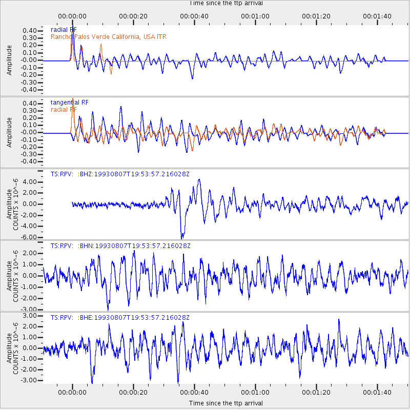
Signal To Noise
| Channel | StoN | STA | LTA |
| TS:RPV: :BHN:19930807T19:53:57.216028Z | 1.2290751 | 5.121401E-7 | 4.166874E-7 |
| TS:RPV: :BHE:19930807T19:53:57.216028Z | 1.1544363 | 4.1405048E-7 | 3.586603E-7 |
| TS:RPV: :BHZ:19930807T19:53:57.216028Z | 4.7055335 | 1.2139543E-6 | 2.5798442E-7 |
| Arrivals |
| Ps | 8.8 SECOND |
| PpPs | 31 SECOND |
| PsPs/PpSs | 40 SECOND |


